Subject: World
Period: 1790 (circa)
Publication: New, Royal, and Authentic System of Universal Geography
Color: Hand Color
Size:
17.5 x 10.6 inches
44.5 x 26.9 cm
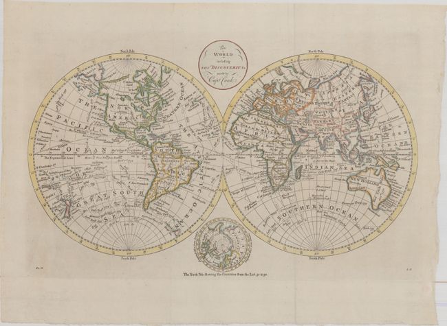
This attractive double-hemisphere world map depicts the voyages and discoveries of Captain James Cook. Alaska is shown with a fairly correct shape with a notation along its northern coastline, "according to the Japanese." The Sandwich Islands are shown and noted as the place where Capt. Cook was killed. The South Pacific is filled with islands, and New Zealand is fully formed. Tasmania is still attached to Australia, which is shown with an unexplored coastline between Lewins Land and Diemens Land.. There are numerous notations throughout and the tracks of Cook's three voyages. An inset of the North Pole, showing a less developed Alaska, is tucked between the hemispheres at bottom with the title cartouche balancing the composition at top. This is the second state with the addition of "82H" at bottom left and "8G" at bottom right. Published in Thomas Bankes' New, Royal, and Authentic System of Universal Geography.
References: McCorkle (18th C. Geography Books) #11-3.
Condition: A
A clean and bright example, issued folding, now flattened on paper with the watermarks of a fleur-de-lis and "IV." There is minor printer's ink residue and a crease at bottom left.