Subject: Colonial New England United States
Period: 1729 (circa)
Publication: Galerie Agreable du Monde
Color: Black & White
Size:
14.4 x 11.4 inches
36.6 x 29 cm
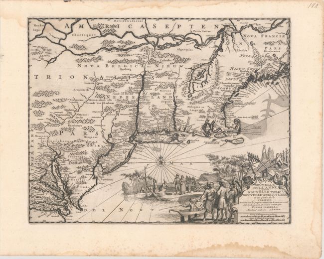
This beautiful engraving is the second state of the plate originally issued by Arnoldus Montanus in 1671 with the title Novi Belgii, quod nunc Novi Jorck Vocatur, Novae qz. Angliae & Partis Virginiae Accuratissima et Novissima Delineatio. Based on the inflential Jansson-Visscher series, the map includes the placement of nearly every European settlement along the coastline and rivers. It covers the Eastern seaboard from just below the Chesapeake Bay to Pennobscot Bay. Most of the interior details appear sketchy and speculative and are occupied by large forests and mountains. Many of the place names have been revised to reflect the loss of the Dutch colony to the British in 1664. While Nieuw Nederlandt still appears for the region, the city is named Nieu Jorck, the Dutch Fort Organie is named Nova Albania, and Nieu Jarsey is now named. The elaborate title cartouche depicts Native Americans interacting with European settlers.
References: Burden #411; McCorkle #729.1; Campbell (MCC-24) #22.
Condition: B+
A dark impression on a bright sheet with a fleur-de-lis coat of arms watermark. There are damp stains along the top and bottom sheet edge, just entering the image at top left.