Subject: North America
Period: 1835 (circa)
Publication: Depot de la Guerre
Color: Hand Color
Size:
14.8 x 10.7 inches
37.6 x 27.2 cm
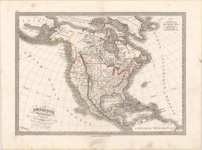
The United States and Great Britain established in 1818 joint claim over the Oregon Territory - the region north of Spanish controlled Upper California up to the southern boundary of Russia's Alaska Territory at North latitude 54°40'. By the late 1830's this arrangement was beginning to fall apart.
In the 1840's the expansionist Democrats, including their 1844 presidential candidate, James Polk, claimed the entire region for the United States. Their expansionist desires were expressed by Polk's famous campaign slogan, "Fifty-four Forty or Fight!" The slogan also became a rally cry for Americans desiring to settle the territory. Following Polk's election, the dispute was resolved by the 1846 Treaty of Oregon, which struck a compromise that fixed the U.S./Canadian boundary at 49º North.
This uncommon copper-engraved map portrays the United States extending well into British Columbia, which was eventually known as the Fifty-four Forty or Fight controversy, cartographically taking the side of the United States. The Rocky Mountains are called the Montagues Rochieuses. The Great Salt Lake is called Lake Timpanogos with the smaller Lake Teguya below. Several river systems cross the Great Basin area. Alaska is Russie Americaine, and all of Canada is Nouvelle Bretagne. Fancy titling with flourishes and a keyboard-style border embellish the map. This is an early edition of this map, prior to the addition of Texas as a Republic. Engraved by Lale.
References:
Condition: A
A nice impression with contemporary outline color and soiling that is mostly in the blank margins and a bit in the north Pacific Ocean.