Subject: Holy Land
Period: 1588 (published)
Publication: Cosmographey oder Beschreibung Aller Lander...
Color: Hand Color
Size:
6.6 x 10.3 inches
16.8 x 26.2 cm
Sebastian Munster (1489 - 1552) was one of the three most renowned cartographers of the sixteenth century, along with Mercator and Ortelius. Munster's Geographia and Cosmographia Universalis were two of the most widely read and influential books of the period. His editions of Ptolemy's Geographia, published between 1540 and 1552, were illustrated with 48 woodcut maps, the standard 27 Ptolemaic maps supplemented by 21 new maps. These new maps included a separate map of each of the known continents and marked the development of regional cartography in Central Europe. The antique geography was a prelude to Munster's major work, the Cosmographia, which was published in nearly 30 editions in six languages between 1544 and 1578 and then was revised and reissued by Sebastian Petri from 1588 to 1628. The Cosmographia was a geographical as well as historical and ethnographic description of the world. It contained the maps from the Geographia plus additional regional maps and city views with nearly 500 illustrations which made it one of the most popular pictorial encyclopedias of the sixteen century.
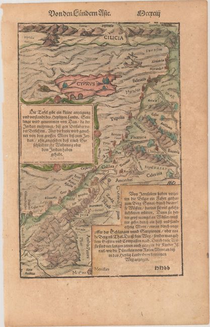
This graphic woodblock map of the Holy Land covers the region from southern Turkey to the Nile Delta and prominently includes Cyprus. The River Jordan has two sources according to the medieval conception, with the name of the river composed from the two names: Jor and Dan. There are two inset panels of German text. German text on verso.
References: Laor #528; Shirley (BL Altases) T.MUN-1l #215.
Condition: B+
Light toning with a small worm hole in the left blank margin and light damp stains along the edges of the sheet.