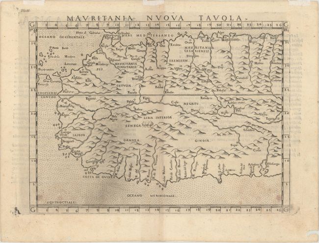
Subject: Western Africa
Period: 1574 (published)
Publication: La Geografia di Claudio Tolomeo Alessadrino…
Color: Black & White
Size:
9.6 x 7 inches
24.4 x 17.8 cm
Claudius Ptolemy was a mathematician, astronomer and geographer who worked in Alexandria, then a part of the Roman Empire, in the 2nd century AD. One of the most learned and influential men of his time, his theories dominated both astronomy and geography for nearly 1500 years. His writings were kept alive by Arabic scholars during the Middle Ages and reemerged in Europe during the Renaissance. The birth of printing led to wide dissemination of his great works on astronomy and geography. There were a number of editions of his Geographia beginning in 1477. These early editions contained maps based on his original writings, known as Ptolemaic maps. As geographic knowledge increased with the explorations of Columbus, Magellan, Cabot and others, maps of the New World were added, and maps of the Old World were revised. Ptolemy's Geographia continued to be revised and published by some of the most important cartographers including Martin Waldseemuller, Sebastian Munster, Giacomo Gastaldi, Jodocus Hondius, and Gerard Mercator (whose last edition was published in 1730).
A very early map of the region. This Italian version of Ptolemy describes many rivers, enlarged lakes, anthill style mountains, and a stipple engraved sea. From the third Italian edition, revised and corrected by Giovanni Malombra and printed by Giordano Ziletti in Venice.
References: Norwich #313; Mickwitz & Miekkavaara #220-47.
Condition: B+
There is light soiling along the bottom border and a hint of toning along the centerfold.