Subject: North America
Period: 1795-1840 (circa)
Publication:
Color: Black & White
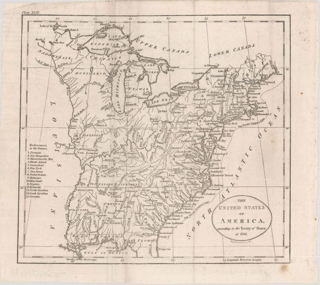
A. The United States of America, According to the Treaty of Peace of 1784, by John C. Russell, circa 1795 (7.9 x 7.2"). A very early map that details the fledgling states and the Indian lands east of the Mississippi River. The map is particularly interesting for the depiction of the Revolutionary War Bounty Land Grants. Ohio is a small area labeled Ohio Company and Donation Lands with no sign of the other bounty grants named on Russell's larger, derivative map. Other interesting designations west of Ohio bear the labels Illinois Company, Wabash Company, Army Lands, and New Jersey Company. The area northeast of the upper Mississippi River is largely unorganized with a few rivers, forts, and settlements. The map locates Detroit, the Lake of the Woods, and Upper and Lower Iowa in this region. Army Lands are located in both Kentucky (unnamed) and in the Tennessee Government. Tennessee had recently split from western North Carolina and would soon gain statehood. Georgia is listed at the fifteenth state and appears to extend to the Mississippi River. Florida is divided into east and west regions. Under the control of Spain, Florida had been ceded by England to the Spanish in gratitude for their neutrality during the American Revolutionary War. Various Indian tribes, forts, and villages are indicated throughout. The Twenty Leagues Line is drawn in the Atlantic. Near the left margin is the "References to the States," listing only fifteen. The title misdates the Treaty of Paris to 1784, instead of 1783. Ref: McCorkle #795-11. Condition: Issued folding on paper with a "1795" watermark, some extraneous creases, and minor soiling. (B+)
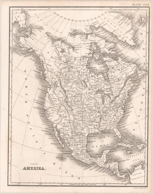
B. North America, by George Aikman, circa 1840 (7.6 x 9.8"). This handsome small map of North America identifies towns and cities, forts, Indian tribes, rivers, and mountains. Texas is named and depicted with no defined borders. A large Missouri Territory appears to the east of the Rockies. California and much of the Southwest are still part of Mexico, but the Mexican border is incomplete, adding some ambiguity. The Western Territory in the Pacific Northwest extends to Queen Charlotte's Island, reflecting American interests in the Oregon Boundary Dispute. Alaska is Russian Territory. Condition: Marginal toning. (A)
References:
Condition:
See description above.