Subject: Africa
Period: 1598 (published)
Publication: La Geografia de Claudio Tolomeo Allessadrino…
Color: Black & White
Size:
9.8 x 7.1 inches
24.9 x 18 cm
Claudius Ptolemy was a mathematician, astronomer and geographer who worked in Alexandria, then a part of the Roman Empire, in the 2nd century AD. One of the most learned and influential men of his time, his theories dominated both astronomy and geography for nearly 1500 years. His writings were kept alive by Arabic scholars during the Middle Ages and reemerged in Europe during the Renaissance. The birth of printing led to wide dissemination of his great works on astronomy and geography. There were a number of editions of his Geographia beginning in 1477. These early editions contained maps based on his original writings, known as Ptolemaic maps. As geographic knowledge increased with the explorations of Columbus, Magellan, Cabot and others, maps of the New World were added, and maps of the Old World were revised. Ptolemy's Geographia continued to be revised and published by some of the most important cartographers including Martin Waldseemuller, Sebastian Munster, Giacomo Gastaldi, Jodocus Hondius, and Gerard Mercator (whose last edition was published in 1730).
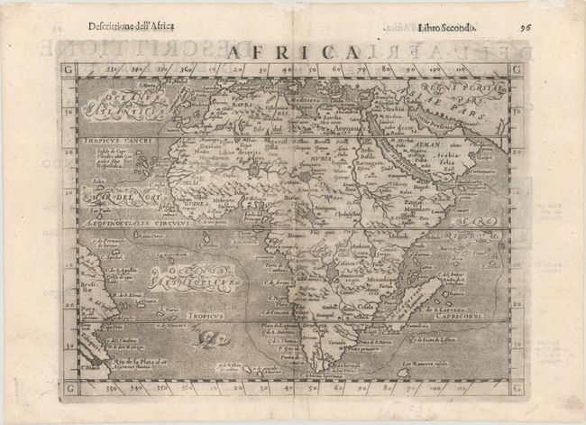
This uncommon map shows the entire continent of Africa surrounded by stippled seas in the typical Italian style. The rivers of central and northern Africa feature prominently including the Ptolemaic concept of the origin of the Nile in two lakes south of the Equator. The largest of these lakes also has a river flowing southeast. As is seen in many maps from this period, Zanzibar is incorrectly located on the west coast. Decorated by a menacing-looking sea monster in the south Atlantic Ocean. This is the fourth Italian edition of Ptolemy by Ruscelli, revised, enlarged and edited by Gioseppe Rosaccio and printed in Venice by the heirs of Melchior Sessa. This map was one of the new continental maps added by Rosaccio for this edition. Italian text on verso.
References: Mickwitz & Miekkavaara #227-48; Shirley (BL Atlases) T.PTOL-10f.
Condition: B+
A dark impression with a narrow strip along the centerfold that has been replaced with old paper. A tiny amount of image loss has been replaced in facsimile. There is light text show-through from verso.