Subject: Southeast Asia, Mediterranean, World War II
Period: 1944 (dated)
Publication:
Color: Printed Color
Size:
57.2 x 38.2 inches
145.3 x 97 cm
These very large pictorial maps were produced by the Educational Services Section of the U.S. Navy. One of the division's primary goals was to inform American service members of the status of the war and to provide context for the battles they would be supporting. Each map is filled with graphic illustrations and related text, providing the reader with a vivid depiction of each theater of war.
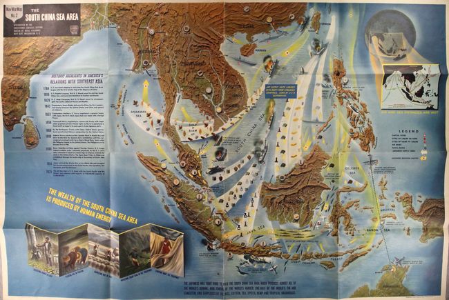
Map #2 (verso) depicts a host of wartime events along with a history of United States relations with Asia from 1784-1925 at left. The map vividly shows numerous Japanese invasion routes in yellow and their supply lines in white along with a note at center indicating "Jap Supply Ships Loaded with Booty from Conquered Countries, sunk by U.S.N. submarines." Numerous battle scenes are depicted throughout including the sinking of H.M.S. Repulse, H.M.S. Prince of Wales, and H.M.S. Langley. General MacArthur's route from the Philippines to Australia is shown at right. The map is further decorated with several illustrations at lower left demonstrating "The Wealth of the South China Sea Area is Produced by Human Energy." A vivid depiction of the events in the Pacific theater of war.
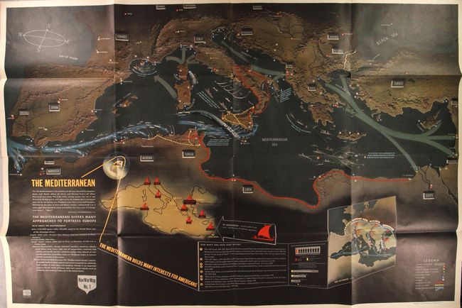
Map #1 (recto) is densely filled with illustrations and text with particular emphasis on the Allied fleet along the north African coast and the many islands in the Mediterranean including Sardinia, Malta, Sicily, and Crete. An inset map filling the interior of Africa shows the sites of past wars in the Mediterranean with the note "Our Navy Has Been Here Before." A second inset shows the extended range of Allied Bombers into mainland Europe. A legend at bottom right identifies naval bases, airfields, British Army lines, U.S. Army lines, and possible invasion routes. A striking view of the events in the Mediterranean theater of war.
References: Curtis & Pedersen (War Map) pp. 184-187.
Condition: B+
Issued folding in vivid color with some short splits at fold intersections and minor wear along a couple of folds.