Subject: Colonial North America
Period: 1762 (circa)
Publication:
Color: Hand Color
Size:
23.8 x 17.9 inches
60.5 x 45.5 cm
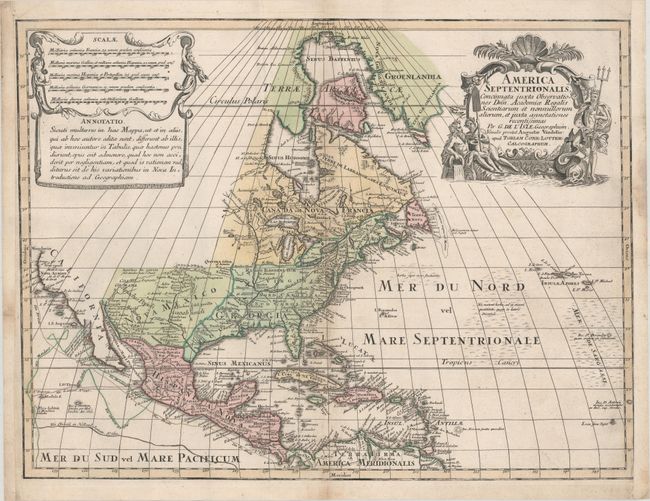
This is a very uncommon German version of Guillaume Delisle's foundation map of North America (1700), not to be mistaken for the similar Jeremias Wolff edition of 1710 or the later Lotter edition (circa 1772) with updated cartouches. The Great Lakes are based on the Coronelli model showing the French strong points at Tadousac, Quebec, Fort Sorel, Montreal, and Fort Frontenac. The English settlements are confined along the eastern seaboard with the region around the Great Lakes and north of the Ohio River being the domains of the Ilionensium and Iroquoens. As with Delisle's map the Mississippi River is properly aligned, as are the Rio Grande and Colorado rivers, and California appears as a peninsula. Numerous tracks in the Pacific show the routes of different voyages. The Sargasso Sea is graphically shown in the Atlantic. Graphically the map copies Delisle's title, distance scale, and notation cartouches.
References: cf. McCorkle #700.4; cf. Portinaro & Knirsch CXXIV; Sellers & Van Ee #126; Tooley (America) #34, p. 19.
Condition: B+
A crisp impression on sturdy paper with a horizontal printer's crease at top left and light soiling. The left margin has been extended and the right side has been remargined, both with old paper. Remnants of hinge tape on verso.