Subject: Asia
Period: 1705 (published)
Publication: Algemeene Weereldbeschryving
Color: Hand Color
Size:
10.7 x 7.4 inches
27.2 x 18.8 cm
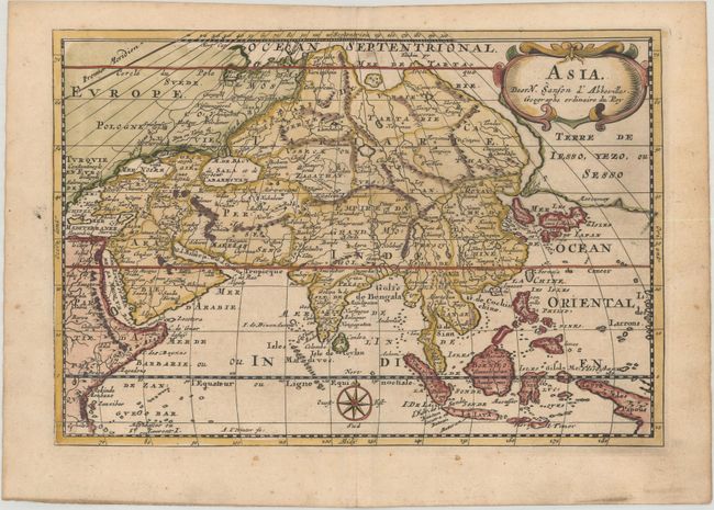
Attractive and intriguing map of the continent and the East Indies with the cartography of the larger Sanson map of 1652. This map shows a large and dramatic version of Terre de Jesso, drawn from the discoveries of the Maarten de Vries expedition of 1643. Here Sanson incorporated De Vries' information by combining Hokkaido and the southern Kurils into a huge island, shown with the two place names of le Tessoy P and Matzumay. Korea is depicted as an island. This version of the map extends another 10° east to include part of New Guinea, identified here as the Terre de Papous. Beautifully engraved by Antoine de Winter.
Sanson's small maps from his L'Asie en Plusieurs Cartes..., first published in 1652 and engraved by A. Peyrounin, were copied several times by various map publishers. Johann David Zunners made copies of Sanson's maps for his German translation of Die Gantze Erd-Kugel in 1679. Johannes Ribbius and Simon de Vries published copies in 1682 and 1683, with new maps engraved by Antoine d'Winter. The plates were later sold to Francois Halma, who used them in 1699 and then again in 1705 with the titles re-engraved in Dutch. The titles on the d'Winter plates were re-engraved back into French, and then used by Nicholas Chemereau in 1715 and by Henri du Sauzet in 1738.
References: cf. Yeo #47.
Condition: A
A sharp impression with a couple of tiny spots of foxing and light toning along the edges of the sheet.