Subject: Volga River, Russia
Period: 1664 (published)
Publication: Grooten Atlas
Color: Hand Color
Size:
22.3 x 18.8 inches
56.6 x 47.8 cm
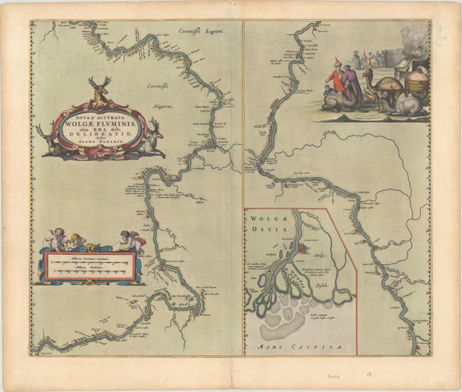
Uncommon map of the Volga River in two parts based on the travels of Adam Olearius. The left side of the map begins at Nazhniy Novgorod and ends at Saratov. The right side continues to Astrakhan with an inset of the river delta. Richly embellished with a strapwork title cartouche featuring reindeer, a scale cartouche with putti, and a fine pictorial scene of an encampment with camels. Dutch text on verso.
Adam Olearius was a German scholar, mathematician, geographer and librarian. He was sent in 1633 by Duke Frederick III to Moscow and Persia to seek treaties favoring the newly-founded city of Friedrichstadt as the terminus for an overland silk road. The party traveled from Hamburg to Moscow via Lubeck, Riga, Dorpat, Revel, Narva, Ladoga and Novgorod. A favorable treaty was struck with Michael Romanov in 1635. Later that year Olearius returned to Moscow and then on to Persia via the Volga and the Caspian Sea. After an arduous journey he met the shah in August 1637, but negotiations were not successful. On the return trip, Olearius left his party at Revel heading directly for Lubeck. He mapped the Volga along the way, bringing this knowledge to Europe.
References: Van der Krogt (Vol. II) #1825:2.
Condition: A
A crisp impression on a sheet with an Atlas watermark. There is some light offsetting and a tiny tear near the centerfold at top only visible when held to light. Hinge tape remnants on verso.