Subject: Paris, France
Period: 1578 (published)
Publication: Cosmographey oder Beschreibung Aller Lander…
Color: Black & White
Size:
12.9 x 10.1 inches
32.8 x 25.7 cm
Sebastian Munster (1489 - 1552) was one of the three most renowned cartographers of the sixteenth century, along with Mercator and Ortelius. Munster's Geographia and Cosmographia Universalis were two of the most widely read and influential books of the period. His editions of Ptolemy's Geographia, published between 1540 and 1552, were illustrated with 48 woodcut maps, the standard 27 Ptolemaic maps supplemented by 21 new maps. These new maps included a separate map of each of the known continents and marked the development of regional cartography in Central Europe. The antique geography was a prelude to Munster's major work, the Cosmographia, which was published in nearly 30 editions in six languages between 1544 and 1578 and then was revised and reissued by Sebastian Petri from 1588 to 1628. The Cosmographia was a geographical as well as historical and ethnographic description of the world. It contained the maps from the Geographia plus additional regional maps and city views with nearly 500 illustrations which made it one of the most popular pictorial encyclopedias of the sixteen century.
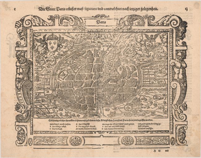
This charming, woodblock view of the walled medieval city of Paris represents the capital in about 1530. A lettered key at bottom identifies important places. The surrounding countryside is filled with small walled estates, windmills, and farmland, while in the foreground two bodies dangle from the gallows. The plan is adorned with coats-of-arms and is surrounded by a striking border with Gothic figures. German text on verso. Another title runs across the top of the page: Die Statt Paris Eclicher Map Figuriert und Contrafehtet nach Ietziger Gelegenheit.
References: Mickwitz & Miekkavaara #158-35.
Condition: B+
There is some light soiling and foxing mostly outside of the map image. Remnants of paper in the top corners of the sheet on verso.