Subject: Southwestern United States
Period: 1871 (dated)
Publication:
Color: Black & White
Size:
22.1 x 28.6 inches
56.1 x 72.6 cm
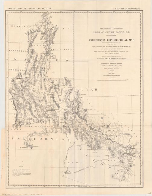
The 1870s was a period of intense effort, by such prominent people as Clarence King, Ferdinand Hayden, and John Wesley Powell, to advance the geographical knowledge of the West. These various surveys presented a threat to the Army's supremacy in the field of mapping and to the related appropriations from Congress. As a result of these pressures, the Army Corp of Engineers developed a plan to systematically survey the entire West to be called the U.S. Geographical Surveys West of the One Hundredth Meridian. The region was divided up into 95 rectangles, with atlas sheets to be prepared for each, comprising an area 2°45' of longitude and 1°40' of latitude on a scale of eight miles to the inch. Lieutenant George Wheeler was chosen to head this immense project. Surveys were conducted each summer from 1872 to 1878, after which Congress cut off appropriations for field work; thus the survey was not completed as originally envisioned. Wheeler published annual reports from 1873 to 1884, as well as the final Geographical Report published in 1889. The maps from this report are a valuable document of the record of Western exploration.
This map was the result of Wheeler's spectacular exploration of 1871. The sudden emergence of the Interior Department's civilian surveys posed a major threat to the military's mapping and exploration efforts. Wheeler, barely 30 years of age, was tasked to gather information and produce a highly accurate map of the area. Having accomplished this, he conceived of the U.S. Geographical Surveys West of the One Hundredth Meridian, of which this map is the forerunner.
The map is very detailed with scores of mining districts located and named. Wheat refers to it as a "map of great interest." Wheeler was modest regarding the map's construction and in the notations announced that the map "is a hasty and partial compilation from the topographical data already received, many still remaining en route." The map displays a portion of Nevada together with parts of California, Utah and Arizona, as bounded by Tucson, San Bernardino and the Sierra Nevadas, St. George, and north to Mountain City, above Elko.
References: Wheat (TMW) #1237.
Condition: A
Issued folding with a few faint spots and a hint of offsetting. Binding trim at top left.