Subject: Central United States
Period: 1867 (dated)
Publication: Final Report of the United States Geological Survey of Nebraska
Color: Hand Color
Size:
31.5 x 43.3 inches
80 x 110 cm
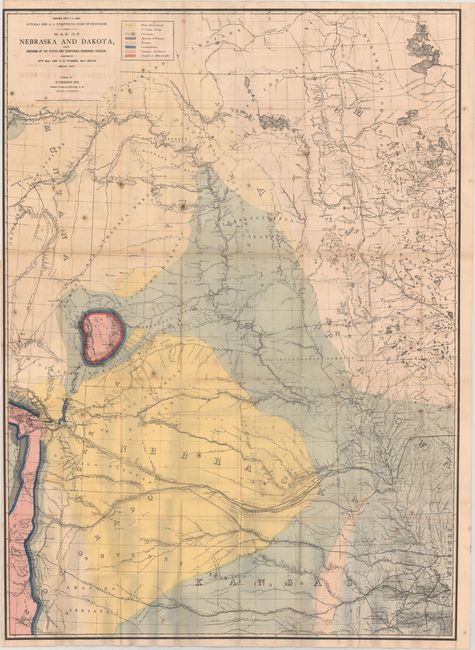
This is a remarkable edition of Warren’s map that has been amended to show geological features provided by Dr. Ferdinand Hayden, then Professor of Geology and Mineralogy at the University of Pennsylvania. It illustrates the geology of the northwestern Great Plains region extending from the Canadian border south to Pueblo, Colorado, and from the Colorado Front Range east to Leavenworth, Kansas. The map itself provides a comprehensive view of the surveys and exploration of the region, including those of the Government Land Office, Pacific Railroad Surveys, Stansbury, Fremont, Nicollet and others, It is one of Hayden’s earliest and most distinctive large geological maps with the Black Hills shown as a brightly colorful "bull's eye," surrounded by pastel shaded tertiary formations. The map also provides excellent detail of railroads, including the Union Pacific, and dozens of forts and Indian ranges. The color key to the right of the title identifies eight different geological types. The map was published in Hayden's "Final Report of the United States Geological Survey of Nebraska" of 1872.
References: Marcou & Marcou #628.
Condition: B
Issued folding with scattered foxing, light offsetting, and several minor fold separations. Trimmed close to the border at left, as issued.