Subject: North Pacific Ocean
Period: 1784 (circa)
Publication: New... Voyages Round the World...
Color: Hand Color
Size:
12.8 x 8.3 inches
32.5 x 21.1 cm
Captain James Cook (1728-1779) is best known for his three voyages to the Pacific (1768-71; 1772-75; and 1776-79). His discoveries radically changed the western understanding of the world in the late 18th century. He was the first to circumnavigate and chart New Zealand and provided the earliest European accounts of exploration along the eastern coast of Australia and the Hawaiian Islands. On February 14th, 1779, he was killed on Hawaii after attempting to kidnap the chief of the island.
Many contemporary accounts of Cook’s voyages, including charts and engravings, appeared in the late 18th century. The first official account of Cook’s first voyage was published in 1773 by John Hawkesworth in Volumes II and III of An Account of the Voyages Undertaken by the Order of His Present Majesty for Making Discoveries in the Southern Hemisphere... William Strahan and Thomas Cadell published the first official accounts of the second and third voyages in 1777 and 1784. Accounts of his exploration were subsequently translated into French, German, and Dutch.
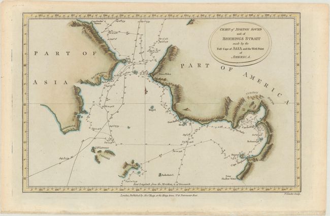
This chart covers the area on either side of the Bering Strait including Norton Sound with the Resolution's route detailed with day-to-day notations during Cook's voyage in 1779. Details include sections of the coastline and islands with many place names, soundings and anchorages.
References:
Condition: A
A crisp impression with marginal toning.