Subject: Africa
Period: 1692 (dated)
Publication: Atlas Nouveau
Color: Hand Color
Size:
34.6 x 21.3 inches
87.9 x 54.1 cm
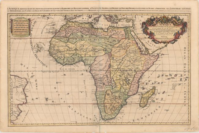
This striking map is the Mortier version of Jaillot's 1674 map of the continent of Africa. It can be distinguished from the earlier Jaillot map of Africa by the date and minor changes in the title in the top margin and it does not carry the engraver's imprint. Based on Sanson's second map of Africa (1668), it presents the standard Ptolemaic description of the source of the Nile. However, Jaillot introduced a new depiction of the rivers south of these Ptolemaic lakes. The Zambeze River appears above the Zambere and Rio de Spiritu Santo, all of which flow into the Indian Ocean. A large section of South America is shown and two St. Helena islands appear - a common error in maps from this period. The drape-style distance scale cartouche has six scales. The very large and decorative title cartouche is filled with symbols of Africa, including native figures, cornucopias, an elephant, a crocodile, a lion and an ostrich under the coat of arms of the Dauphin. Two sheets joined, as issued. This is the first state.
References: Betz #156.1; cf Norwich #46.
Condition: B+
A nice, sharp impression with contemporary color in the map and later color in the cartouches. There is some light offsetting, a few spots of foxing in the map, and archivally repaired centerfold separations. The margins have some short tears that are well away from the image.