Subject: Southwest United States & Mexico
Period: 1824 (published)
Publication: A New General Atlas
Color: Hand Color
Size:
11.1 x 8.4 inches
28.2 x 21.3 cm
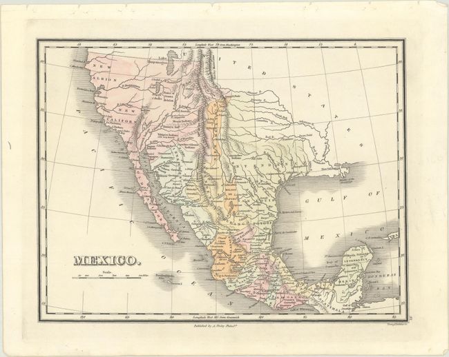
Finely's maps employ a delicate and elegant engraving style and provided extensive topographical and watershed information. He was the dominant map maker in the United States in the early 1820s into the 1830s. His atlases were very successful, outselling rival atlases by Carey & Lea, and Tanner. His maps were printed on high quality paper and were routinely corrected and updated.
This terrific, detailed map delineates mountains, watershed, and towns. Baja is Old California and to the north are New California and New Albion. The map features numerous Indian tribes including Moqui (Hopi), Yamaya, Yabipias, Apaches, Nochi, etc. The large, mythical Lake Timpanogos appears in the region of Utah. A smaller Salt Lake is the source of the erroneous Buenaventura River that flows into the Pacific at San Francisco. Another mythical river, the River San Felipe originates in southern Utah and flows to the Pacific Ocean below Monterey Bay in the vicinity of today's Big Sur. Beautifully engraved by Young & Delleker.
References: Phillips (Atlases) #4314-31; Day #1470A and 1505.
Condition: A+
A fine example with binding holes in the top blank margin, as issued.