Subject: United States & Mexico
Period: 1845 (dated)
Publication: Modern Atlas, Physical, Political and Statistical...
Color: Hand Color
Size:
18 x 10.8 inches
45.7 x 27.4 cm
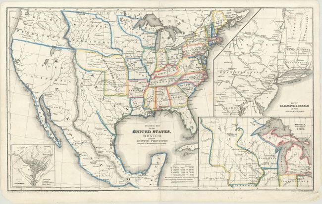
This fascinating map of the United States and Mexico depicts Texas on the cusp of statehood, with unusual transitional boundaries. On this example, the colorist has left Texas' western border undefined. A narrow New Mexico territory is wedged between Texas and the Rocky Mountains. West of the Rockies is a vast Upper California, with Oregon Territory named in the northwestern United States. The Wisconsin, Iowa, and Indian territories are also identified. Missouri is shown both as state and territory. The American Fur Depot appears on the shore of the unnammed Great Salt Lake. J. Greggs Route to Santa Fe and the Route of the Santa Fe Caravans are delineated. Insets show a plan of Washington, D.C., a map of railways and canals in parts of the Mid-Atlantic and New England, and a more detailed view of Michigan and the Iowa and Wisconsin territories. A key at bottom indicates the sizes of towns and cities, capital cities, canals, and railways. Engraved by J.M. Atwood.
References: Rumsey #1229.012.
Condition: B+
A 7.5" tear at left has been expertly repaired on verso. Short centerfold separations at top and bottom have been closed on verso with archival materials.