Subject: Texas
Period: 1860-66 (dated)
Publication:
Color: Hand Color
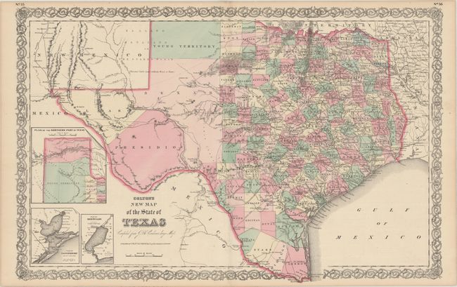
A. Colton’s New Map of the State of Texas Compiled from J. de Cordova’s Large Map, by G.W. & C.B. Colton & Co., dated 1866 (26.1 x 16.9"). This double-page map shows extensive detail throughout the settled part of the state. The western third is comprised of the large unsettled areas of Presidio, El Paso, Bexar and Young Territory. Locates railroads, forts, post offices, roads, springs, and topographical detail. Includes three inset maps: Plan of the Northern Part of Texas, Plan of Galveston Bay from the U.S. Coast Survey, and Plan of Sabine Lake. Surrounded by Colton's decorative scroll borders. Condition: A fine example. (A+)
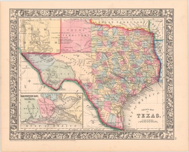
B. County Map of Texas, by S. Augustus Mitchell, dated 1860 (13.4 x 10.7"). One of the most attractive maps of the state of Texas, inset with a map of Galveston Bay, and Vicinity. West Texas is made up of Young Territory, Bexar Territory, El Paso and Presidio counties, and clearly shows the Llano Estacado or Staked Plain with a notation about the region being "destitu[t]e of both wood and water." Erath County is mistakenly identified as "Earth" County. The map shows trails, roads, a limited railroad system that extends only into Austin, and proposed railroads indicated by dashed lines. The map is surrounded by a fine floral border. Copyright date 1860, published circa 1864. The county development is up-to-date for 1864 as Dawson County, abolished in 1866, is included. Condition: A few faint spots. (A)
References:
Condition:
See description above.