Subject: Long Island, New York, Geology
Period: 1914 (published)
Publication: Professional Paper 82
Color: Printed Color
Size:
61.6 x 25.4 inches
156.5 x 64.5 cm
Myron Fuller's report on the The Geology of Long Island, published as Professional Paper 82, contains scores of line drawings, b&w photographs and small maps in addition to the following two impressive maps, each measuring approximately 62 x 25":
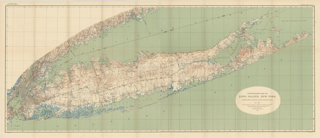
Topographic Map of Long Island, New York. This highly detailed map shows county divisions, roads, cities, towns and railroads. It presents the entire island extending to include New York City, Jersey City and most of Staten Island. There is also exceptional detail along the Connecticut shoreline to Bridgeport. The details are quite remarkable and include small villages, dirt roads or trails, railways, and much more of interest. Topography lines, at 20' intervals, are shown in brown, coastal wetlands in blue, and the Atlantic Ocean and Long Island Sound in green.
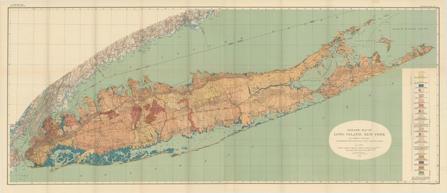
Geologic Map of Long Island, New York. This map adds geological features to the topographical map above. It is color-coded to show 19 different geologic types, which makes for a stunning and informative visual.
Both maps are on two joined sheets, as issued, and lithographed by Julius Bien. Quarto, 231 pages with paper wrappers.
References:
Condition: A+
Condition code is for the maps, which are clean, colorful, and fine. Text and plates are near fine with just a hint of light toning. Paper wrappers are toned along the edges with some scattered foxing. Spine is chipped at top and bottom with some minor tape reinforcement.