Subject: Southern California, Oil
Period: 1900-06 (circa)
Publication:
Color:
This lot contains a rare promotional item from a short-lived company during the L.A. oil boom at the turn of the century as well as six other early U.S.G.S. maps detailing oil development in Southern California:
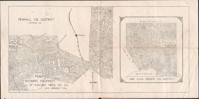
A. Map Showing Property of Railway Mens Oil Co Los Angeles Cal, circa 1900, black & white (10.9 x 5.3"). Two maps on one sheet including the Newhall Oil District (Santa Clarita) and the San Luis Obispo Oil District. Each shows the property of the company and neighboring wells. The verso contains promotional text for the company with strong claims including “…when we strike oil our stock will go up with a bound. Buy now – it will make you rich.” The company operated for a short while in 1900. The company’s ad in the Los Angeles Herald of April 1, 1900 makes the same offer of stock and shows the same two maps listed above. No sales results or institutional holdings on OCLC.
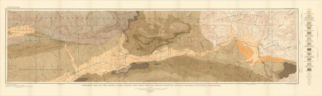
B. Geologic Map of the Santa Clara Valley and Adjacent Oil Fields, Ventura and Los Angeles Counties, California, printed color (48.2 x 12.3"). An attractive geological map of the Santa Clara valley, one of the early centers of the California petroleum industry. It is color-coded to identify 12 different geological types as well as fault lines and oil wells. In addition to the geology, the map provides valuable information on a number of early mountain roads, canyons, and small early settlements in the region.
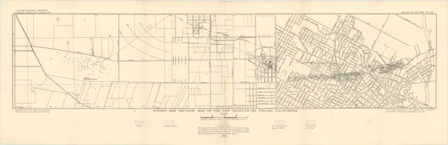
C. Street and Section Map of the Los Angeles Oil Fields, California, black & white (26.5 x 6.0"). This map shows a remarkable number of oil wells in downtown Los Angeles primarily from the L.A. River to Westlake Park. This map was featured in the Library of Congress exhibition on "Los Angeles Mapped" with the following description: "Edward L. Doheny's 1892 discovery of oil near downtown Los Angeles led to an oil boom around the turn of the twentieth century. Hundreds of wells were dug throughout the city, often in the front or backyards of residences."
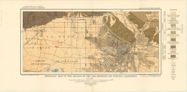
D. Geologic Map of the Region of the Los Angeles Oil Fields, California, printed color (13.8 x 6.5"). Prominently depicts the oil fields downtown and locates the famous La Brea Tar Pits further to the west. Identifies 8 different geological types on the map.
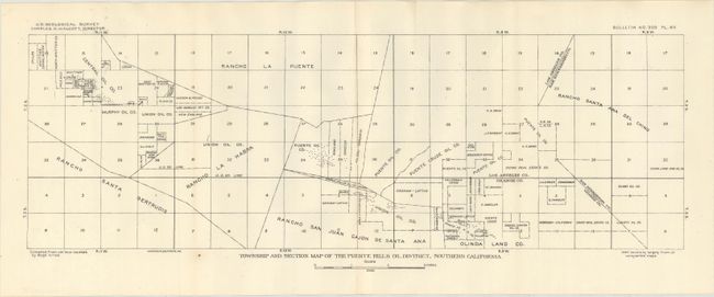
E. Township and Section Map of the Puente Hills Oil District, Southern California, black & white (20.2 x 6.6"). Shows land ownership in the Puente Hills region near the intersection of Los Angeles, Orange, and San Bernardino counties. Much of the land is owned by oil companies including Union Oil, Puente Oil, and Murphy Oil to name a few.
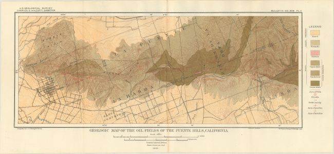
F. Geologic Map of the Oil Fields of the Puente Hills, California, printed color (17.1 x 6.9"). Locates the numerous oil wells to the east of Whittier and identifies 6 geological types on the map.
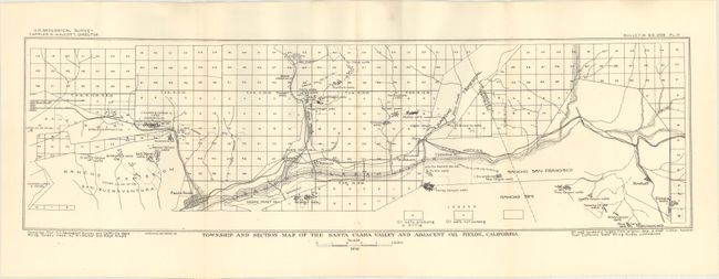
G. Township and Section Map of the Santa Clara Valley and Adjacent Oil Fields, California, black & white (21.9 x 6.3"). Township map of the Santa Clara valley extending from Nordhoff to Newhall and south to Santa Paula. A legend identifies producing and non-producing oil wells and several oil company holdings are identified.
References:
Condition:
The first map is very good (B+) with minor soiling and two closed fold separations confined to the margins. The remaining six maps are near fine to fine (A).