Subject: Colonial New England & Mid-Atlantic United States, Boston
Period: 1757 (circa)
Publication: Histoire Generale des Voyages
Color: Black & White
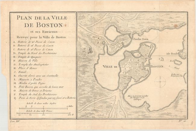
A. Plan de la Ville de Boston et ses Environs, circa 1757 (10.7 x 6.5"). Attractive early plan of Boston and the harbor including Charles Town and Isle Ronde. It shows the street plan of the town and wharves, and locates gun batteries, powder magazines, Presbyterian churches, a prison, a town hall, a windmill, and a beacon. It indicates an offshore anchorage and the entrance channel and also depicts shoreline topography with the roads running down to the harbor. Large key at left lists sixteen important sites. Engraved at bottom neatline is Tom. XIV , No 10.
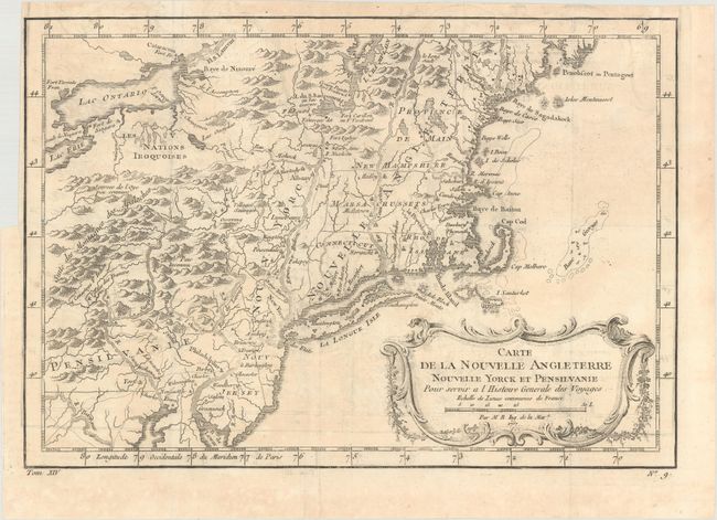
B. Carte de la Nouvelle Angleterre Nouvelle Yorck et Pensilvanie pour Servir a l'Histoire Generale des Voyages, dated 1757 (11.8 x 8.1"). This French & Indian War period map details the English colonies from Pennsylvania through Penobscot Bay in Maine, with their early boundaries. It is fully engraved with topographical features and includes many early place names. The colonies are shown confined east of the Allegheny Mountains with the Nations Iroquoises, Indian villages, and several French forts located west of the mountains. It extends to show Lake Ontario and most of Lake Erie. A flourishing French rococo-style cartouche with distance scale decorates the map. References: McCorkle #757.1; Sellers & Van Ee #721.
References:
Condition: B+
Issued folding on watermarked paper with faint offsetting and a few minor spots. There are short binding trims at left.