Subject: Colonial New England & Mid-Atlantic United States
Period: 1730 (circa)
Publication: Neue Atlas Bestehend...
Color: Hand Color
Size:
22.4 x 18.9 inches
56.9 x 48 cm
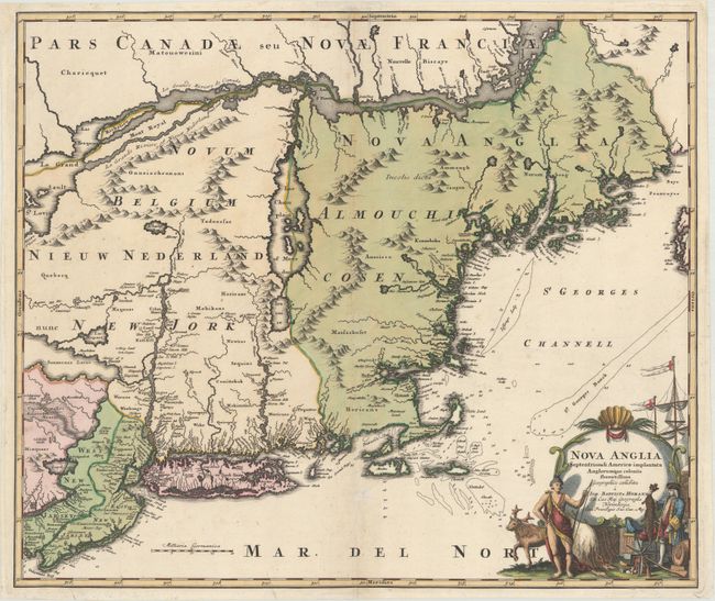
This handsome map shows the English colonies of Nova Anglia and New Jarsey and the Dutch colony of Novum Belgium - Nieuw Nederland - New Jork. It covers the region from Delaware Bay to Eastport, Maine. Numerous soundings and navigation hazards are noted along the coastlines. Oversized lakes appear in the interior of New England and New York, notably Lake Champlain (which is grossly misplaced) and Sennecaas Lacus. Cape Cod and Cape Ann are both depicted as islands and Boston Harbor is exceedingly large. The fictitious region of Norumbeag is placed in present-day Maine at the head of Penebrock Bay. Various Indian tribe names are identified on the map, as are numerous colonial settlements along the coastlines and rivers. The cartouche depicts a European sea captain negotiating with an Indian chief. They are surrounded with trade goods, alluding to the natural wealth of the region.
References: McCorkle #724.1; Portinaro & Knirsch #116; Sellers & Van Ee #806.
Condition: B
A superb, dark impression on watermarked paper with original color in the map and later color in the cartouche. There are several archivally repaired cracks adjacent to the centerfold caused by the oxidation of the green pigment. There are a few minor creases and a tear that enters 1/2" into image at bottom has also been archivally repaired. This map will ship flat.