Subject: Britain
Period: 1956-57 (dated)
Publication:
Color: Printed Color
Size:
24.1 x 38.1 inches
61.2 x 96.8 cm
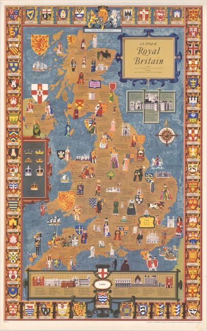
This extremely decorative pictorial map shows England, Wales, Scotland, and Northern Ireland, with an emphasis on the region's royal history. Across the map, there are illustrations of kings and queens, castles, and historical events. There are depictions of Arthur and Guinevere's supposed burial place at Glastonbury; St. Columba in Scotland; St. Augustine converting Aethelberht of Kent; the Siege of Exeter during the Norman Conquest; the execution of Mary Queen of Scots; the landing place of Charles II at his Restoration; the Battle of Culloden; and much more. Panels at right and bottom focus on palaces in Edinburgh and London. Another cartouche at left notes different crowns. There is an elegant title cartouche at top right. The map is surrounded by a border consisting of the coats of arms of various regions. Designed by Kempster and Evans, issued by the British Travel and Holidays Association, and printed in London by Chromoworks Ltd.
References:
Condition: A
Vivid color with a few minor edge tears confined to the blank margins.