Subject: Portobelo, Panama
Period: 1762 (circa)
Publication:
Color: Black & White
Size:
10.2 x 7.8 inches
25.9 x 19.8 cm
Thomas Jefferys was one of the most important English map publishers of the 18th century. His work included prints and maps of locations around the world, but his most notable maps are of North America and the West Indies. He began his career in the map trade in the early 1730s, working as an engraver for a variety of London publishers, and eventually setting up his own shop. In 1746, he was appointed Geographer to the Prince of Wales, and in 1760 he became Geographer to the King. These titles granted access to manuscripts and cartographic information held by the government. In the early 1760s he embarked on an ambitious project to produce a series of English county maps based on new surveys, but ran out of money and filed for bankruptcy in 1766. He then partnered with London publisher Robert Sayer, who reissued many of Jefferys plates and continued to issue new editions after Jefferys' death in 1771. Jefferys' American Atlas and the accompanying West-India Atlas, published post posthumously, are considered his most important cartographic works.
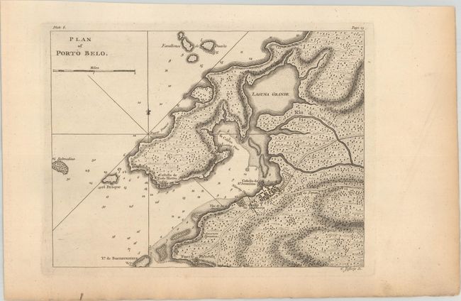
This is a handsome chart of historic Portobello Bay, which was a Spanish transfer point for gold and silver coming from South America. It locates Forte Farnese and the Governors Plantation and presents the town in a simple block pattern, with Old Potobelo immediately to the northeast. Adjacent to the town is the fortified Castello de la Gloria, and across the bay is the Castello de Todo Hierro and a few other buildings. The roads are well detailed including the Road to Panama, which extends off the map on its way to Panama City. In the ocean are a few rhumb lines, depth soundings, hazards, and a fleur-de-lis. The chart likely appeared in either A Description of the Spanish Islands and Settlements on the Coast of the West Indies (1762) or on the same sheet as a plan of Chagres in General Topography of North America and the West Indies (1768).
References: Kapp (MCC-73) #78-1; cf. Phillips (A) #3941-8.
Condition: A
A crisp impression on a watermarked sheet with faint marginal toning.