Subject: Western United States
Period: 1836-59 (circa)
Publication:
Color: Black & White
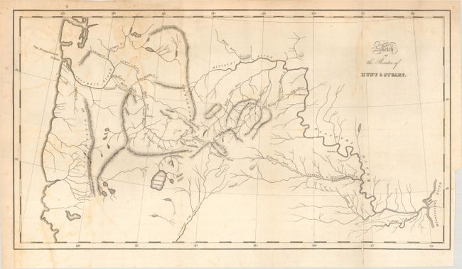
A. Sketch of the Routes of Hunt & Stuart, by Washington Irving, from Astoria, or Anecdotes of an Enterprise Beyond the Rocky Mountains, circa 1836 (17.6 x 9.6"). Describing an expedition launched just a few years after Lewis & Clark's epic journey, this map covers the same region - from the junction of the Mississippi and Missouri, up the Missouri, across the Rocky Mountains and through the Pacific Northwest, extending to well below Lake Bonneville Salt Water. The southern portion of the map is mostly blank except for a long, straight Colorado of the West with many tributaries originating in the Rockies. The Great Basin region has three lakes and a few land-locked rivers. The routes of the two explorers are delineated with dotted lines with Stuart's party reaching all the way to Astoria near the mouth of the Columbia River. Wheat says "for what it purports to be it is an excellent map." The map is the result of a commercial exploration directed by John Jacob Astor. The expedition was sent in 1811 to seek an overland route to the Pacific. Washington Irving was commissioned by Astor to write the account of his company's effort to create a settlement in Oregon. The work and this map were not published until 1836. Reportedly engraved by Carey, Lea & Blanchard, but no attribution is given on the map. Reference: Wheat (TMW) #419. Condition: There is light offsetting, a few minor pencil notations, and a short fold separation at bottom that has been closed on verso with archival tape.
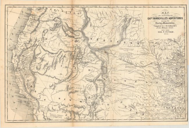
B. Map to Illustrate Capt. Bonneville's Adventures Among the Rocky Mountains, by George P. Putnam/Joseph Hutchins Colton, from The Adventures of Captain Bonneville..., dated 1856 (18.4 x 11.8"). This is a later edition of this interesting map and is based on Fremont's map. The expedition route described is that of Captain Benjamin Bonneville who explored the American West from 1832-1836. The expedition party traveled parallel to the course of the Snake and the Columbia Rivers, going as far as Fort Walla Walla before turning back. Fremont's route through California is shown, as well as Kearny's route along the Gila River and the Emigrant route. References: cf. Wagner-Camp #67:14, cf. Wheat (TMW) #424. Condition: There is light toning along one fold, a few spots of foxing, and a short binding tear at right that has been closed on verso with archival tape.
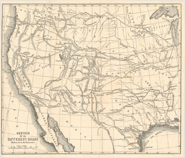
C. Sketch of the Different Roads Embraced in the Itineraries, by Randolph B. Marcy, circa 1859 (11.0 x 9.2"). This map extends from Lake Michigan to the Pacific Ocean and shows the various routes and trails available for emigrants to the West. These routes were described by Marcy in his government sponsored, privately published The Prairie Traveler: A Handbook for Overland Expeditons. Condition: There are a few short fold separations that have been closed on verso with archival tape.
References:
Condition: B+
Issued folding. See description above for additional details.