Catalog Archive
Auction 175, Lot 152

"Guide Through Ohio, Michigan, Indiana, Illinois, Missouri, Wisconsin & Iowa. Showing the Township Lines of the United States Surveys...", Smith, J. Calvin

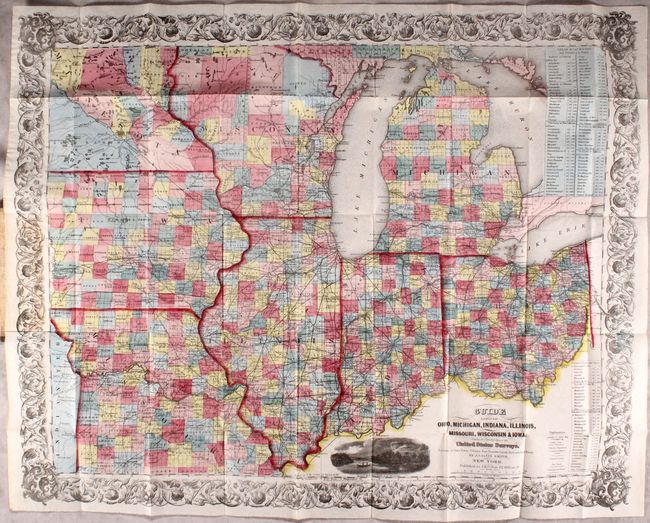
Subject: Central United States

Period: 1854 (dated)

Publication:

Color: Hand Color

Size:
25.9 x 20.8 inches
65.8 x 52.8 cm
Download High Resolution Image
(or just click on image to launch the Zoom viewer)

This beautifully engraved pocket map was issued as a guide for travelers and immigrants. It is densely filled with information on Stage Roads, railroads, political divisions, towns and villages, watershed and canals. The areas of Minnesota and northern Wisconsin are sparsely settled. Two large tables lists the routing and distances for Steam Boat Routes throughout the area. The map is embellished with a decorative floral border and the engraved vignette "Maidens Rock, Lake Pepin on the Mississippi." Folds into stiff brown boards (3.7 x 5.7") with gilt title "Map of the Western States" by J.H. Colton.

References: cf. Karpinski p. 260.

Condition: A

The map is clean, bright, and in remarkable condition with a few tiny splits at the fold junctions. Boards have minor wear and are a bit sunned.

Estimate: $400 - $475

Sold for: $300

Closed on 11/13/2019

Archived