Subject: Exploration & Surveys, Pacific Ocean
Period: 1773 (published)
Publication:
Color: Black & White
Size:
9.3 x 11.5 inches
23.6 x 29.2 cm
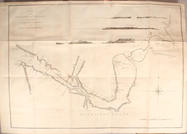
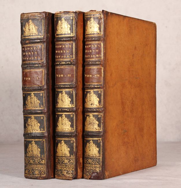
This is the first edition of John Hawkesworth's account of the most important 18th century British explorations in the Pacific. Volume one concerns the explorations of Byron, Wallis and Carteret, while volumes two and three are fully dedicated to Captain Cook. The present example includes 49 of the 52 issued plates, with all the important charts present including A Chart of the Straights of Magellan, which is only found in the earliest examples of this work. Of particular interest are the following charts:
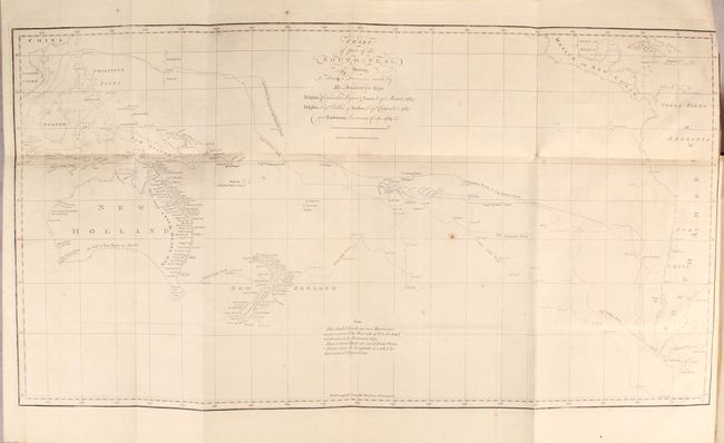
Chart of Part of the South Sea, Shewing the Tracts & Discoveries Made by His Majesty's Ships... (26.3 x 14"). This chart of the South Pacific covers the region from Australia and Southeastern Asia to the western coast of South America, and is filled with the tracks of the explorers Cook, Byron, Wallis, and Cateret. Lands that are shaded indicate new discoveries by these parties and include eastern Australia, most of New Zealand, portions of New Guinea, and the Society Islands. Cook's new place names appear along the eastern coast of Australia including Botany Bay, C. Banks, and Pt. Solander.
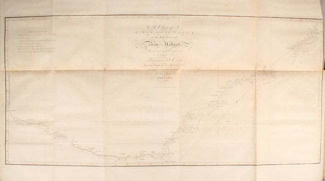
A Chart of New South Wales, or the East Coast of New-Holland. Discover'd and Explored by Lieutenant J. Cook... (30.9 x 14.3"). This is the first published chart of the east coast of Australia. The map shows the routes of the Endeavor with names bestowed by Cook, including Botany Bay, which was named for the large quantities of plants located there. The chart is oriented with north to the right by a delicate fleur-de-lis and soundings are located along the route.
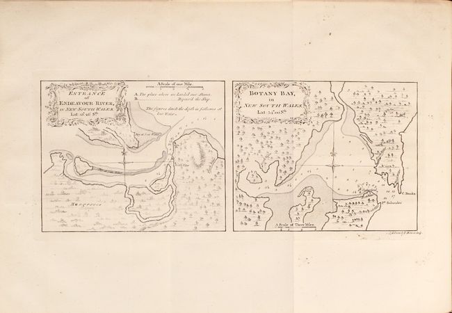
Entrance of Endeavour River, in New South Wales... [on sheet with] Botany Bay, in New South Wales... (13.2 x 5.3"). Two charts on one sheet. The chart on the right is the depiction of Sydney Harbor when Cook first landed in Australia on April 29, 1769. Locates C. Banks and Pt. Solander which were named by Cook for his botanists Joseph Banks and Daniel Solander. The chart on the left shows entrance of the Endeavour River in northern Queensland. It locates the "place where we Landed our Stores" and the place where we "Repair'd the Ship." Cook departed Botany Bay continuing northwards where, on June 11, the Endeavour ran aground on a shoal of the Great Barrier Reef. The ship was badly damaged and his voyage was delayed for seven weeks while repairs were accomplished on the site marked on this map. This is near the town of Cooktown. After the repairs were completed the voyage continued and resulted in Cook claiming the entire eastern coastline of Australia on August 22 for England.
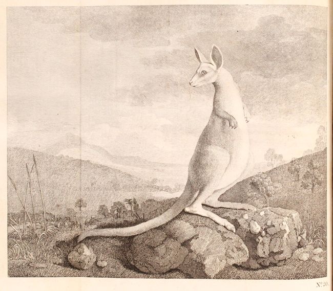
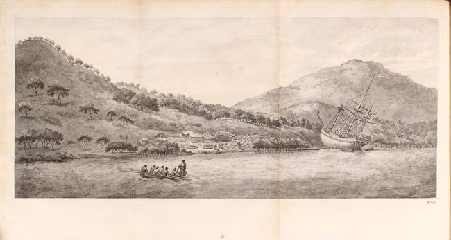
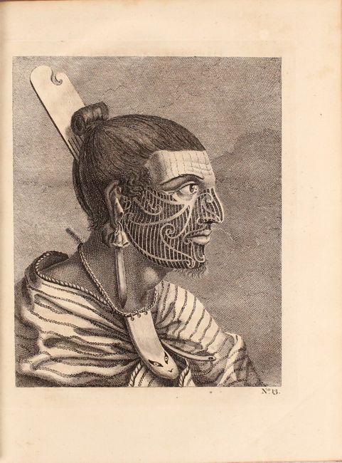
In addition to the charts, this first edition includes 23 plates of illustrations mostly from the Cook expedition featuring depictions of natives and scenery from Tahiti, the Society Islands, New Zealand and Australia. Among the many fascinating plates is the first depiction of a kangaroo in printed form.
While Hawkesworth was paid handsomely to edit these accounts on behalf of the British Admiralty, Cook was displeased with the result and edited his own account for the second and third expeditions. Quarto, rebacked with contemporary leather boards and original spine backstrips.
References: Shirley (BL Atlases) G.HAWK-1a; Sabin #30934.
Condition: B+
Maps are generally very good with light toning and occasional light to moderate offsetting and sporadic foxing. Text is very good with occasional toning. A former owner's bookplate is present on the front pastedown of each volume. Rebacked with original spine labels, and covers have average shelf wear.