Subject: Arabia, Red Sea, East Africa
Period: 1700 (circa)
Publication:
Color: Hand Color
Size:
29.8 x 20.6 inches
75.7 x 52.3 cm
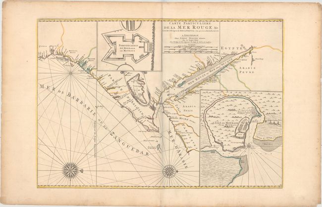
This boldly engraved sea chart covers the Red Sea and the Gulf of Aden with portions of Yemen and the east coast of Africa from modern Tanzania to Suez. There are three inset maps: a plan of Fort Mombassa, a map of Mombassa Island, and a small map of the island of Socotra. Babel Mandel appears in the seaway between the southern Red Sea and the Gulf of Aden, and Zanzibar is shown in the south. The map is oriented with north to the right by two spectacular compass roses. It likely appeared in either Atlas Suite de Neptune Francais or Atlas Nouveau Contenant les Parties du Monde.
References: Norwich #262; Pastoureau, JAILLOT IF #357.
Condition: A
A dark impression on a sheet with wide margins and original outline color. There are a few faint spots adjacent to the centerfold and minor toning along the sheet edges.