Subject: Mexico, Baja California
Period: 1710 (circa)
Publication: Atlas Novus
Color: Black & White
Size:
13.8 x 9.1 inches
35.1 x 23.1 cm
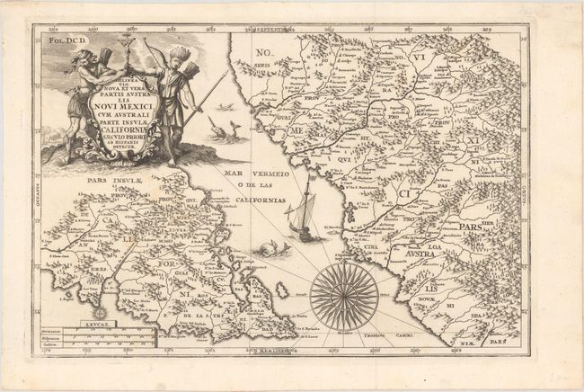
A lovely, decorative map of the tip of Baja California and a portion of northwest Mexico with parts of Sonora and Sinaloa. California is shown as an island, although only the southern tip is shown. This map was drawn by Scherer after a 1685 manuscript map sent to him from New Spain by his compatriot, Jesuit missionary Father Eusebio Francisco Kino. Kino's explorations in the region eventually led to his realization that California was not an island, but that conclusion had not yet been reached when this map was created. The map is widely regarded as the first detailed mapping of any portion of the interior of the Baja, showing missions, settlements, mountains, rivers, etc. It is adorned with a cartouche featuring natives holding a crucifix representing the missionary goals of the Jesuits in North America. The sea teems with monsters and a galleon, and a large compass rose is shown in the Mar Vermeio. Heinrich Scherer, professor of mathematics at Munich, was a devout Jesuit whose work emphasizes the Catholic hierarchy and the spread of Jesuit missions throughout the world.
References: McLaughlin #158; Shirley (BL Atlases) T.SHER-1a #27.
Condition: A
Issued folding on a bright sheet with a couple of faint spots.