Subject: United States & Mexico, Texas
Period: 1839 (dated)
Publication: Mitchell's School and Family Geography
Color: Hand Color
Size:
16 x 10.3 inches
40.6 x 26.2 cm
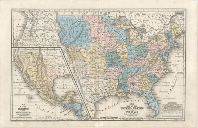
This is an earlier, uncommon edition of this great school atlas map featuring the Independent Republic of Texas in an odd configuration with Houston as its capital instead of Austin. Texas appears in a squat form, with the panhandle labeled as New Mexico. The huge Indian Territory lies north of Texas and extends to the Missouri Territory, which in turn goes to the Canadian border. Stretching from the Texas-New Mexico border up through Indian Territory is the massive Great American Desert. Oregon Territory covers the northwest and extends well into Canada. Iowa Territory is in a rare configuration, spanning from the northern border of the state of Missouri to Canada and bounded east and west by the Mississippi and Missouri Rivers. Population figures appear around major towns and cities. The large inset at lower left is a detailed Map of Mexico and Guatemala and also shows the Republic of Texas, and details the Spanish holdings in North America.
References:
Condition: B+
A few short separations along the centerfold have been archivally repaired on verso. There are some manuscript notations in pencil.