Subject: Kentucky & Tennessee
Period: 1834 (dated)
Publication:
Color: Black & White
Size:
44.9 x 22.9 inches
114 x 58.2 cm
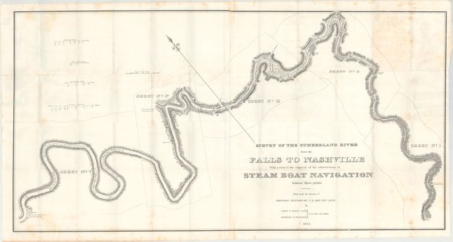
This scarce map shows the route from below Barboursville, Kentucky, to the confluence of the Cumberland River and the Great South Fork, just above Nashville. It is from Howard Stansbury's report and survey concerning the practicability of extending steam boat navigation up the Cumberland River. The region surrounding the upper Cumberland River was rich in mineral resources and Congress wanted to understand the feasibility of removing natural obstacles in order to access these resources. The map includes four cross sections titled: Shadowen's Shoal, White Cliff Ripple, End of Smith's Shoals, and Long Shoal. It is decorated with an elaborate compass point and terrific lettering in the title, which exactly matches the fancy lettering used on steamboats. This is an early work by Stansbury, who eighteen years later commanded an important expedition to Utah. A large (two-sheets joined) and early map that is very uncommon.
References: Claussen & Friis #43.
Condition: B+
Issued folding on a bright sheet with scattered foxing.