Subject: Southwestern United States & Mexico, Texas
Period: 1825 (dated)
Publication: Atlas Universel de Geographie...
Color: Hand Color
Size:
19.4 x 18.4 inches
49.3 x 46.7 cm
Vandermaelen was the son of a wealthy industrialist who abandoned his father's business to follow a career in cartography. His goal was to produce the first atlas ever published in which every map was drawn on the same projection and to the same scale (1: 1,641,836), with each map covering an area of approximately 20 degrees of longitude (from Paris) and 6 degrees of latitude. Because of the consistent scale and projection, the maps could be joined together to form a huge globe that would measure over 25 feet in diameter. Vandermaelen had the only known globe constructed from his maps, requiring a special room for its display. It was also the first lithographic atlas ever published. There was one edition of the atlas, published in 1825-27, and the subscription list shows that only 810 copies were sold. Koeman called his Atlas Universel, "One of the most remarkable world atlases ever made. Far ahead of its time."
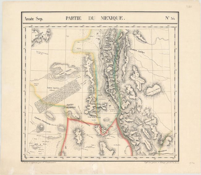
This uncommon sheet centers on the Rio Grande and includes parts of northern Mexico, Arizona, New Mexico, and Texas. There is intricate topographical detail, and the map locates Indian lands, with a special emphasis on the Apache presence in the region. The information was gathered from Spanish sources and Humboldt’s Carte Generale...Nouvelle Espagne (1809).
The Atlas Universel contained 400 maps in six volumes. It was the first atlas made up of lithographed maps, and the first to present all the maps on the same scale (1: 1,641,836), with each map covering an area of approximately 20 degrees longitude (from Paris) and 6 degrees of latitude. If all the maps were joined together they would form a globe of 7.75 meters in diameter. The maps were published by subscription between 1825 and 1827, with each part containing ten maps. There was only one edition and the subscription list shows that 810 copies were sold; thus the maps are quite rare.
References: TCU (TX) Plt. 15.
Condition: A
A nice example with some archivally repaired edge tears confined to the bottom blank margin.