Subject: New Zealand
Period: 1774 (circa)
Publication: Cartes et Figures des Voyages…
Color: Black & White
Size:
14.8 x 18.7 inches
37.6 x 47.5 cm
Captain James Cook (1728-1779) is best known for his three voyages to the Pacific (1768-71; 1772-75; and 1776-79). His discoveries radically changed the western understanding of the world in the late 18th century. He was the first to circumnavigate and chart New Zealand and provided the earliest European accounts of exploration along the eastern coast of Australia and the Hawaiian Islands. On February 14th, 1779, he was killed on Hawaii after attempting to kidnap the chief of the island.
Many contemporary accounts of Cook’s voyages, including charts and engravings, appeared in the late 18th century. The first official account of Cook’s first voyage was published in 1773 by John Hawkesworth in Volumes II and III of An Account of the Voyages Undertaken by the Order of His Present Majesty for Making Discoveries in the Southern Hemisphere... William Strahan and Thomas Cadell published the first official accounts of the second and third voyages in 1777 and 1784. Accounts of his exploration were subsequently translated into French, German, and Dutch.
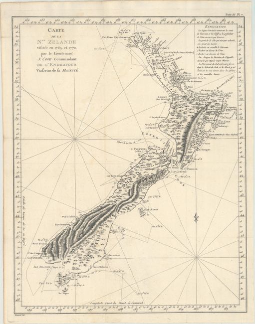
This is one of the most important maps in New Zealand's history and the first complete map of the two islands' coastlines. The chart was made during Cook's first voyage and shows the track of the Endeavour with dates and soundings. The interior reflects the mountainous topography. From the French edition published by Hawkesworth and engraved by Benard.
Capt. James Cook sailed from England in 1768 on his ship the Endeavour on his first round-the-world voyage visiting islands in the Pacific before sighting New Zealand's north & south islands and the strait that divides them, which he named Cook's Strait. Between 1769-1770 Cook sailed around both islands, proving that they were independent of the Great Southern Continent, which was what navigators had believed since Abel Tasman discovered the land mass in 1642. This finely engraved map was taken from a sketch brought back to London by Cook in 1771, which was published in English in London by Cadell & Strahan in 1773, and in French in Paris in 1774.
References: Tooley (Australia) p. 47 #339.
Condition: B+
A dark impression, issued folding and now flattened, on watermarked paper with a couple of minor spots and a professionally repaired 1" tear in an unengraved area of the map at top center.