Subject: Central Asia
Period: 1618 (published)
Publication: Theatrum Geographiae Veteris…
Color: Hand Color
Size:
16 x 13.6 inches
40.6 x 34.5 cm
Claudius Ptolemy was a mathematician, astronomer and geographer who worked in Alexandria, then a part of the Roman Empire, in the 2nd century AD. One of the most learned and influential men of his time, his theories dominated both astronomy and geography for nearly 1500 years. His writings were kept alive by Arabic scholars during the Middle Ages and reemerged in Europe during the Renaissance. The birth of printing led to wide dissemination of his great works on astronomy and geography. There were a number of editions of his Geographia beginning in 1477. These early editions contained maps based on his original writings, known as Ptolemaic maps. As geographic knowledge increased with the explorations of Columbus, Magellan, Cabot and others, maps of the New World were added, and maps of the Old World were revised. Ptolemy's Geographia continued to be revised and published by some of the most important cartographers including Martin Waldseemuller, Sebastian Munster, Giacomo Gastaldi, Jodocus Hondius, and Gerard Mercator (whose last edition was published in 1730).
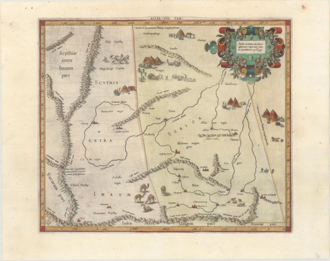
This fine copper engraved map covers Central Asia east of the Caspian Sea in what is now Tajikistan, Kyrgyzstan and western China. The Himalayas and Northern India run across the bottom of the map. The map includes several quaint scenes of the local people, encampments, camel herds, and the capture of wild horses. Mercator originally published this map in his 1578 edition of Ptolemy's great Geography. Although he is most renowned today for the projection he popularized and for first using the term Atlas for a collection of maps, he devoted much of his life to his Ptolemaic maps. The maps were beautifully engraved as nearly as possible to their original form and embellished with fine cartouches. Published in Petrus Bertius' Theatrum Geographiae Veteris… in 1618, which included maps by Mercator, Ortelius, and newly engraved maps by Pieter van den Keere. Latin text on verso.
References: Van der Krogt (Vol. I) #0928:1.1.
Condition: A
A dark impression on a bright sheet with some minor separations along the centerfold that have been professionally repaired and a small paper flaw in the blank margin at top right.