Catalog Archive
Auction 172, Lot 573

"Carte de l Empire Othoman Consideree dans les Etats de Cette Puissance, et des Etats qui l'Avoisinent ou qui luy sont Tributaires...", Chatelain, Henry Abraham

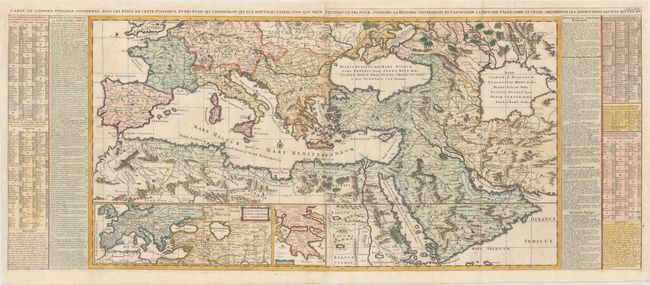
Subject: Mediterranean & Middle East

Period: 1720 (circa)

Publication: Atlas Historique

Color: Hand Color

Size:
47.5 x 19.7 inches
120.7 x 50 cm
Download High Resolution Image
(or just click on image to launch the Zoom viewer)

This grand map shows the extent of the Ottoman Empire with comparisons to the Empires of Alexander the Great and the Romans. It covers the Mediterranean, southern Europe, and northern Africa and extends to the Caspian Sea, Persia, and the Arabian peninsula. Below are two insets, one of an area similar to the large map and the other of the Peloponnese (Greece). At the sides, tables describe the countries and towns depicted on the maps, together with historical notes on the Empire of Alexander the Great and the Roman Empire. Two sheets joined, as issued.

References:

Condition: A

A crisp impression on bright, watermarked sheets, issued folding with a few tiny tears confined to the blank margins and a hint of toning along the joint.

Estimate: $650 - $800

Unsold

Closed on 4/17/2019

Archived