Subject: Peru
Period: 1798 (dated)
Publication: Atlas de la America del Sur
Color: Hand Color
Size:
22 x 33.9 inches
55.9 x 86.1 cm
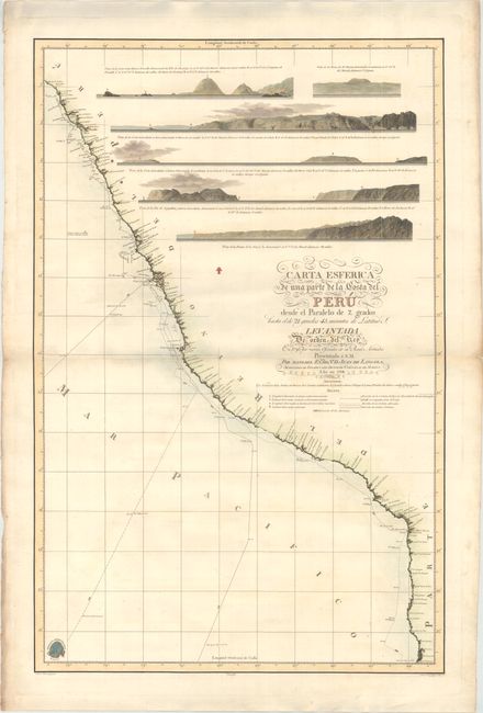
This rare and impressive, large-scale chart details the coastline from about Chiclayo, Peru to just south of Iquique, Chile. The chart was created to depict the route of the Malaspina Expedition along the coast of Peru in 1790-93. Funded by the Spanish government, this scientific expedition was commanded by Alessandro Malaspina and José de Bustamante y Guerra with the purpose of further exploring the Pacific Ocean. Numerous experts accompanied the expedition, including surveyors, astronomers, cartographers, painters, and botanists. The five-year expedition succeeded in measuring the western coast of North America more precisely than ever before. The tracks of the two ships, Descubierta and Atrevida, are shown on this chart along with depth soundings and navigational hazards. Malaspina was imprisoned upon his return to Spain due to his involvement in a conspiracy to overthrow the government, and most of the findings of his expedition were not published for more than 100 years. The interior of Peru is filled with land approach views. Drawn by Felipe Bauza and engraved by Fernando Selma.
References:
Condition: A
A crisp impression on a sturdy sheet with the watermark of "Joan Serra." There is marginal soiling and a few minor creases and tears along the edges of the sheet. There is a light shadow along the centerfold and top edge of the sheet that is caused by our scanner and does not appear on the map itself.