Catalog Archive
Auction 172, Lot 167

First Printing of Fremont's First Expedition to the Rockies

"Map to Illustrate an Exploration of the Country, Lying Between the Missouri River and the Rocky Mountains, on the Line of the Nebraska or Platte River [bound in] A Report on an Exploration of the Country...", Fremont/Preuss

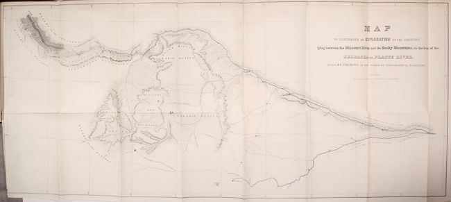
Subject: Western United States

Period: 1843 (published)

Publication: Sen. Doc. 243, 27th Congress, 3rd Session

Color: Hand Color

Size:
32.9 x 14 inches
83.6 x 35.6 cm
Download High Resolution Image
(or just click on image to launch the Zoom viewer)

John C. Fremont is an important historical figure best remembered for his three explorations of the west in the 1840s. Fremont married Jessie Benton, daughter of Sen. Thomas Hart Benton in 1841. The Senator championed the idea of Manifest Destiny, pushing for national surveys of the West and arranging for his son-in-law to lead them.

From 1842 to 1846 Fremont led three explorations of the west with Kit Carson as guide and Charles Preuss as the topographer. His early route became know as the Oregon Trail and his explorations are credited with encouraging the huge overland migration to the west. He was the first American to see Lake Tahoe, and finally determined that the Great Basin is endorheic, or closed basin with no outlet to the sea.

Fremont went on to become a millionaire, a California senator, a governor to Arizona Territory, the man who is credited with saving Kit Carson's life, and much more, yet died penniless and in virtual obscurity. Some scholars regard Fremont as a hero of significant accomplishment, while others view him as a failure who repeatedly defeated his own best ideals. He remains an enigmatic figure in the history of the United States. Read more of his fascinating story here.

This detailed map is from Fremont's first expedition to the Rockies in 1842. It locates Medicine Bow Mountains, New Park Mountains, Wind River Mountains, the Laramie Plains, and St. Vrain's Fort and extends eastward to the confluence of the North and South forks of the Platte River. Fremont surveyed the Oregon Trail as far as South Pass and then explored the Wind River Range of the Rocky Mountains. These mountains form a portion of the Continental Divide and had been the subject of considerable spurious cartography prior to this exploration. Wheat describes the maps as "a highly creditable production" that is free of "imaginary geography." Fremont employed Kit Carson as a guide and Charles Preuss as a cartographer, and despite losing their barometer and other instruments when one of their rafts sank, the expedition was a success and launched Fremont into national prominence. The map is on two joined sheets, as issued.

The map is accompanied by the original and complete 207-page report that includes six illustrative plates (including frontispiece) featuring tinted lithographs of "View of the Wind River Mountains," "Chimney Rock," and "Fort Laramie." Octavo, rebound in gray buckram with paper title label pasted on the spine.

References: Wheat (TMW) #464; Wagner-Camp #95; Streeter #3130.

Condition: A

Condition code is for the map, which is remarkably clean and bright with a short binding tear at left. Plates are also near fine, and the text is very good with scattered foxing. New binding has minimal wear.

Estimate: $700 - $850

Sold for: $2,000

Closed on 4/17/2019

Archived