Subject: Colonial North America
Period: 1762 (dated)
Publication: Atlas Moderne
Color: Hand Color
Size:
17.7 x 12.1 inches
45 x 30.7 cm
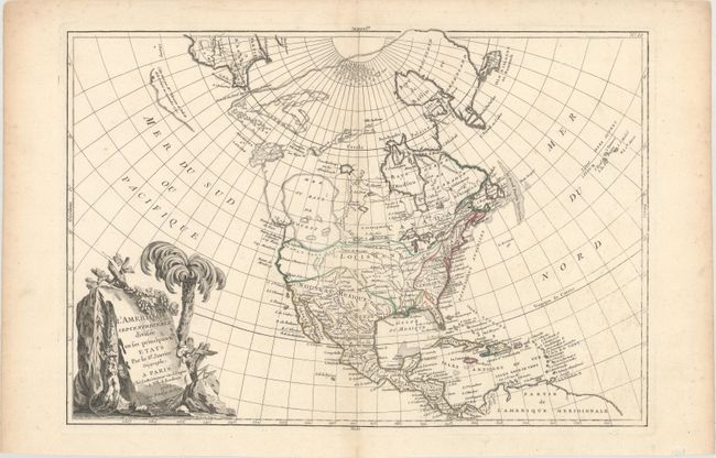
This is the first state of this fascinating map that shows the imaginary Sea of the West and a Northwest Passage stretching from Baffin Bay to the Archipel St. Lazare on the Pacific coast. The gigantic Sea the West, near modern-day Seattle, is connected to the Pacific by the straits of Juan de Fuca and Martin d' Aguilar. New Albion is on the southwest shore of this great inland sea, which inundates virtually all of present-day British Columbia and Alberta. There is not any sign of a recognizable Alaska. The British colonies are confined east of the Appalachian Mountains with French Louisiana stretching to the Pacific Northwest. Florida is controlled by Spain. Ft. Cenis and Santa Fe are visible within the Spanish territories in the southwest, labeled Nouveau Mexique here. The large, decorative title cartouche, incorporating a palm tree and grape vines, was engraved by Berthault.
References: McGuirk #109; Sellers & Van Ee #93.
Condition: A
A nice impression with contemporary outline color on watermarked paper. There is a tiny hole along the centerfold that has been professionally repaired and light soiling in the blank margins.