Subject: Southern Asia
Period: 1541 (published)
Publication: Claudii Ptolemaei Alexandrini Geographicae…
Color: Black & White
Size:
17.6 x 11.7 inches
44.7 x 29.7 cm
Claudius Ptolemy was a mathematician, astronomer and geographer who worked in Alexandria, then a part of the Roman Empire, in the 2nd century AD. One of the most learned and influential men of his time, his theories dominated both astronomy and geography for nearly 1500 years. His writings were kept alive by Arabic scholars during the Middle Ages and reemerged in Europe during the Renaissance. The birth of printing led to wide dissemination of his great works on astronomy and geography. There were a number of editions of his Geographia beginning in 1477. These early editions contained maps based on his original writings, known as Ptolemaic maps. As geographic knowledge increased with the explorations of Columbus, Magellan, Cabot and others, maps of the New World were added, and maps of the Old World were revised. Ptolemy's Geographia continued to be revised and published by some of the most important cartographers including Martin Waldseemuller, Sebastian Munster, Giacomo Gastaldi, Jodocus Hondius, and Gerard Mercator (whose last edition was published in 1730).
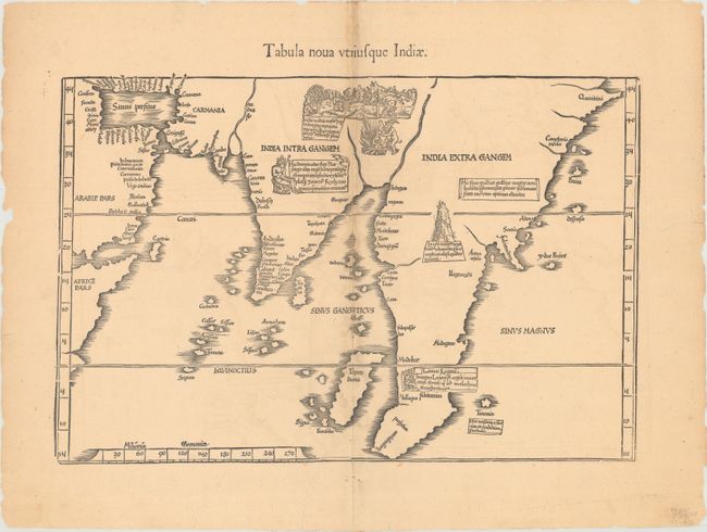
This interesting map is based on Waldseemuller's first "modern" map of southern Asia. It follows that cartography without change but adds an interesting array of vignettes purporting to depict the cultures of the region. The most interesting of these is a scene in Northern India of a goat-like man setting fire to a young woman. The map covers from the Horn of Africa through the Malaysian peninsula and cartographically is a great improvement over Medieval maps of the region. Blank verso.
This edition was printed by Gaspar Treschel and edited by Michael Villanovus (known as Servetus). Servetus was charged with heresy by John Calvin in 1553, in part due to the text in this atlas. The courts found him guilty and sentenced him to burning at the stake, atop a pyre of his own books, including this atlas.
References: Mickwitz & Miekkavaara #211-44.
Condition: B
There is faint offsetting and a 3.75" centerfold separation in the middle of the map that has been closed on verso with archival tape. Several edge tears confined to the blank margins have been closed on verso with old paper.