Subject: Southeast Asia
Period: 1618 (published)
Publication: Theatrum Geographiae Veteris…
Color: Hand Color
Size:
12.9 x 13.6 inches
32.8 x 34.5 cm
Claudius Ptolemy was a mathematician, astronomer and geographer who worked in Alexandria, then a part of the Roman Empire, in the 2nd century AD. One of the most learned and influential men of his time, his theories dominated both astronomy and geography for nearly 1500 years. His writings were kept alive by Arabic scholars during the Middle Ages and reemerged in Europe during the Renaissance. The birth of printing led to wide dissemination of his great works on astronomy and geography. There were a number of editions of his Geographia beginning in 1477. These early editions contained maps based on his original writings, known as Ptolemaic maps. As geographic knowledge increased with the explorations of Columbus, Magellan, Cabot and others, maps of the New World were added, and maps of the Old World were revised. Ptolemy's Geographia continued to be revised and published by some of the most important cartographers including Martin Waldseemuller, Sebastian Munster, Giacomo Gastaldi, Jodocus Hondius, and Gerard Mercator (whose last edition was published in 1730).
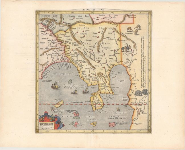
Fine Ptolemaic map of the region of Thailand and Malaysia. The map shows an oddly shaped peninsula to the east of the Ganges and the Sinus Magnus (South China Sea), with a landmass to the east of that. This depiction is the legacy of Ptolemy's idea of a landlocked Indian Ocean. Although he is most renowned today for the projection he popularized and for first using the term Atlas for a collection of maps, Mercator devoted much of his life to his Ptolemaic maps. The maps were beautifully engraved as nearly as possible to their original form and embellished with fine cartouches and cultural scenes. This map includes a caravan, camels, ships and boats.
Mercator originally published this map in his 1578 edition of Ptolemy's great Geography. Although he is most renowned today for the projection he popularized and for first using the term Atlas for a collection of maps, he devoted much of his life to his Ptolemaic maps. The maps were beautifully engraved as nearly as possible to their original form and embellished with fine cartouches. Published in Petrus Bertius' Theatrum Geographiae Veteris…, which included maps by Mercator and Ortelius.
References: Mickwitz & Miekkavaara #232-27; Van der Krogt (Vol. I) #0931:1.1.
Condition: A
A nice example on a clean bright sheet with professional repairs to some separations along the centerfold.