Subject: Guyana, Suriname, French Guiana
Period: 1671 (circa)
Publication: America...
Color: Hand Color
Size:
14.1 x 11.2 inches
35.8 x 28.4 cm
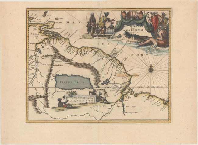
Montanus' work was perhaps the greatest illustrated book on the New World produced in the seventeenth century. It contained over one hundred beautifully engraved plates, views, and maps of North and South America. The plates vividly depict forts, festivals, occupations, Dutch fleets, battles, religious rites, and customs of the native inhabitants. This important work was translated into German by Olivier Dapper, and into English by John Ogilby. Several of the plates were later acquired by Pierre Vander Aa.
This decorative map covers the region from the Isla Margarita in the northwest to the coast of northern Brazil near Sao Luis east of the Amazon delta. The map is based on the work of Hessel Gerritsz who traveled in the region in 1628. The map locates at its center a large mythical inland sea, Parime Lacus, on whose northwestern shore lies the fabled city Manoa, o el Dorado, or the golden city of the Incas. The search for this city led many explorers, including Sir Walter Raleigh, on wild adventures through the jungles. The map is richly embellished with a very large title cartouche and distance scale, both flanked by native Brazilians, a river god representing the Amazon, and Mercury.
References:
Condition: B+
A dark impression with a few small spots of foxing, a stain at "C. de Noord" (to the left of the compass rose), two short centerfold separations that have been professionally repaired, and some light creasing along the centerfold at top.