Subject: Oklahoma
Period: 1837 (dated)
Publication: Sen. Doc. 120, 25th Congress, 2nd Session
Color: Black & White
Size:
19.9 x 10.8 inches
50.5 x 27.4 cm
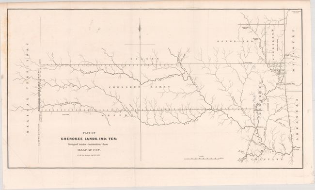
This is one of the earliest printed maps to depict present-day Oklahoma in any detail. It shows a track of land that extends from the borders of Missouri and Arkansas to the "Western Limits of the United States" (100° W. Longitude from Greenwich). The map was drawn at the conclusion of the "Trail of Tears" and shows the furthest extent of the land reserved to the Cherokees, as well as several other reservations (part of which are in what is present-day Kansas). A terrific and early Indian Territory map surveyed by J.C. McCoy under Isaac McCoy's direction, dated in the plate Sept. 20th, 1837.
References: Clausen & Friis #188.
Condition: A
Issued folding with faint foxing along the upper left border, and a minor extraneous crease at bottom left.