Subject: Northwestern United States
Period: 1861-68 (circa)
Publication:
Color: Hand Color
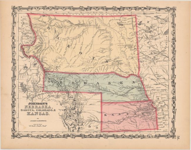
A. Johnson's Nebraska, Dakota, Colorado, & Kansas, by Johnson & Browning, circa 1861 (15.4 x 12.5"). This colorful map features Nebraska with a long panhandle that extends all the way to about present-day Idaho near Ft. Bridger and Fremont's Peak. Above Nebraska is a huge Dakota Territory that extends all the way to the Canadian border, west to the Continental Divide and east to Minnesota Territory. The map is filled with information and locates numerous Indian tribes, trading posts, wagon roads and trails, exploration routes, mountain peaks, and more. Shows the railroad routes explored by Gov. Stephens, Lt. Beckwith, and Capt. Gunnision, as well as numerous forts and early settlements. The Oregon Trail is shown but not named and several other emigrant roads are shown including several converging on Denver. Names the North, Middle, and South Parks, as well as several forts and a few towns in Colorado. Colorado’s western boundary is not defined and the former Utah designation remains just above the “C” in Colorado indicating an 1862 date is likely. According to the Johnson Map Project, this is version 3.0. Condition: There are a few minor stains and light toning along the sheet edges.
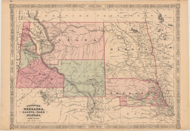
B. Johnson's Nebraska, Dakota, Idaho and Montana, by Johnson and Ward, dated 1865 (23.4 x 17.2"). This colorful double-page map published circa 1865-66 shows a very early rendering of Wyoming Territory, organized in 1868. The territory's western boundary is not correctly formed; a pointed projection extends into present-day Idaho in the northwest, with Idaho occupying western Wyoming south of Jackson Hole. The map correctly delineates Montana which, along with Wyoming, was previously contained in a large Idaho territory. Dakota Territory, from which Wyoming was formed, remains undivided. There is excellent detail throughout with scores of place names, roads, watershed, topography, the Emigrant Road, forts, springs, routes of exploration and proposed railroads. The route of the Pony Express & U.S. Mail Route through Utah, Wyoming and Nebraska is delineated. According to the Johnson Map Project, this is version 1.0. Condition: There is light toning primarily along the centerfold, minor foxing, and a repaired 6" centerfold separation at bottom.
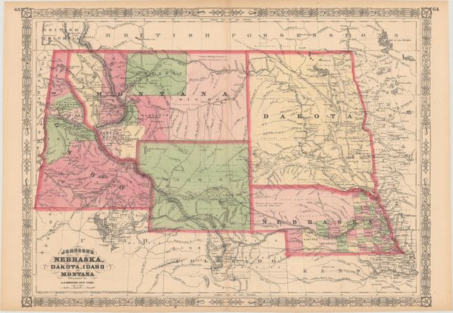
C. Johnson's Nebraska, Dakota, Idaho and Montana, by A.J. Johnson, dated 1865 (23.4 x 17.0"). While dated 1865, this map was published circa 1867-68 according to the Johnson Map Project (version 2.5). The map is very similar to the one above with more county development in western Montana and Wyoming has now a flattened northwestern border. Condition: There is a short centerfold separation at bottom that is closed on verso with archival tape.
References:
Condition: B+
See description above.