Subject: Western Hemisphere - America
Period: 1700 (dated)
Publication: L'Atlas Curieux ou le Monde...
Color: Hand Color
Size:
13.1 x 8.9 inches
33.3 x 22.6 cm
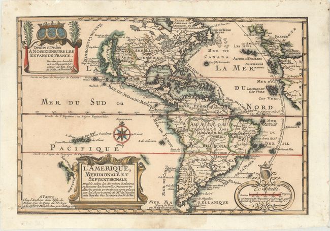
This is the first state of this charming map of the Americas. It is a reduced derivative of De Fer's classical wall map of 1698 with information gathered from the archives of the Academie Royale des Sciences. The island of California covers the entire west coast of North America north of the Tropic of Cancer with two large imaginary islands off shore. One of the prominent features in northern Mexico is Les Mine de S. Iean et de Ste. Barbe, the legendary Santa Barbara mines of the Chihuahua-Durango region. There are several large spurious lakes on both continents. A partial coastline of New Zealand appears beside the title cartouche. The map is richly decorated with three cartouches and a compass rose.
References: Burden #759; McLaughlin #135, Pastoureau, FER I A #5; Tooley (Amer) #61, p. 126.
Condition: B+
A dark impression with light soiling and a spot of color offsetting in the North Atlantic. The sheet has been trimmed to the neatline and is pasted on a sheet of old paper to extend margins.