Subject: Northern Africa
Period: 1535 (published)
Publication: Claudii Ptolemaei Alexandrini Geographicae…
Color: Black & White
Size:
17.5 x 11.6 inches
44.5 x 29.5 cm
Claudius Ptolemy was a mathematician, astronomer and geographer who worked in Alexandria, then a part of the Roman Empire, in the 2nd century AD. One of the most learned and influential men of his time, his theories dominated both astronomy and geography for nearly 1500 years. His writings were kept alive by Arabic scholars during the Middle Ages and reemerged in Europe during the Renaissance. The birth of printing led to wide dissemination of his great works on astronomy and geography. There were a number of editions of his Geographia beginning in 1477. These early editions contained maps based on his original writings, known as Ptolemaic maps. As geographic knowledge increased with the explorations of Columbus, Magellan, Cabot and others, maps of the New World were added, and maps of the Old World were revised. Ptolemy's Geographia continued to be revised and published by some of the most important cartographers including Martin Waldseemuller, Sebastian Munster, Giacomo Gastaldi, Jodocus Hondius, and Gerard Mercator (whose last edition was published in 1730).
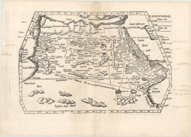
This fine Ptolemaic map comes from the blocks of Laurent Fries, the famous physician, astrologer, and geographer. It covers the regions of Africa that were known to the ancients. The twin lake sources of the Nile are located near the Mons Lune (Mountains of the Moon). In Libya, the Niger River is prominently featured, with its source in several interior lakes and mountains ranges. Prester John, the legendary Christian king, is pictured in Ethiopia. Published in Lyon by Melchior and Gaspar Treschsel. This edition was printed from the same blocks as those in the 1525 edition with wear showing in the lower side borders. Title on verso with Latin text and woodcut borders and ornaments that have been attributed to Hans Holbein.
This map is from the atlas often referred to as 'editio prima Serveti' after its editor, Michael Villanovus, better known as Servetus, who was burned alive in 1553 for heresy. The map of the Holy Land from this atlas had on its verso a comment suggesting that the area was not as beautiful and fertile as generally believed, but was actually barren, according to travelers. This statement was one of the pieces of evidence used against Servetus. Calvin had many copies of the 1535 atlas confiscated and burned with Servetus.
References: Mickwitz & Miekkavaara #209-30; Norwich #287.
Condition: A
There is minor soiling along the centerfold and a small worm hole on the centerfold at bottom. Old manuscript notations are confined to the blank margins.