Subject: Southern Alaska
Period: 1784 (circa)
Publication: A Voyage to the Pacific Ocean...
Color: Hand Color
Size:
12.4 x 9.9 inches
31.5 x 25.1 cm
Captain James Cook (1728-1779) is best known for his three voyages to the Pacific (1768-71; 1772-75; and 1776-79). His discoveries radically changed the western understanding of the world in the late 18th century. He was the first to circumnavigate and chart New Zealand and provided the earliest European accounts of exploration along the eastern coast of Australia and the Hawaiian Islands. On February 14th, 1779, he was killed on Hawaii after attempting to kidnap the chief of the island.
Many contemporary accounts of Cook’s voyages, including charts and engravings, appeared in the late 18th century. The first official account of Cook’s first voyage was published in 1773 by John Hawkesworth in Volumes II and III of An Account of the Voyages Undertaken by the Order of His Present Majesty for Making Discoveries in the Southern Hemisphere... William Strahan and Thomas Cadell published the first official accounts of the second and third voyages in 1777 and 1784. Accounts of his exploration were subsequently translated into French, German, and Dutch.
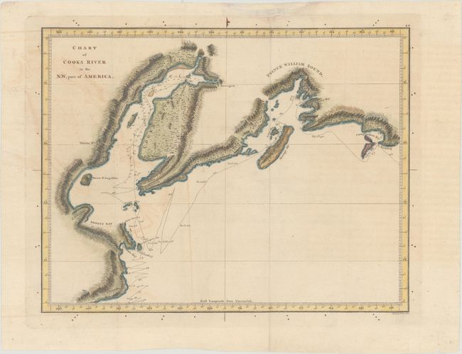
This copper engraving shows Captain Cook's discoveries in Prince William Sound and Cook Inlet during his third and final voyage (1776-1779). Cook landed at Prince William Sound, which he named for the king's third son, on May 12, 1778. It includes track and dated points of the H.M.S. Resolution and the first appearance of Turn-again Arm east of today's Anchorage. Lettering engraved by W. Harrison.
References: Shirley (BL Atlases) G.COOK-2a #12.
Condition: B+
Issued folding, now flattened with light offsetting and toning.