Subject: United States
Period: 1828 (dated)
Publication: Olney's School Atlas
Color: Hand Color
Size:
16.8 x 10.3 inches
42.7 x 26.2 cm
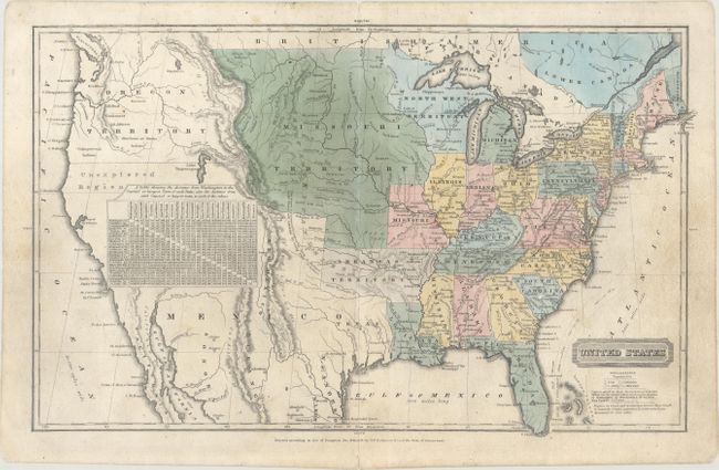
The United States and Great Britain established in 1818 joint claim over the Oregon Territory - the region north of Spanish controlled Upper California up to the southern boundary of Russia's Alaska Territory at North latitude 54°40'. By the late 1830's this arrangement was beginning to fall apart.
In the 1840's the expansionist Democrats, including their 1844 presidential candidate, James Polk, claimed the entire region for the United States. Their expansionist desires were expressed by Polk's famous campaign slogan, "Fifty-four Forty or Fight!" The slogan also became a rally cry for Americans desiring to settle the territory. Following Polk's election, the dispute was resolved by the 1846 Treaty of Oregon, which struck a compromise that fixed the U.S./Canadian boundary at 49º North.
This great map of the United States has early and interesting western territorial configurations. The map shows Texas as part of Mexico, prior to it becoming a republic in 1836. The northern portion of Upper California is marked Unexplored Region, with much of the Southwest conveniently covered by a table of distances. The huge Oregon Territory extends to the Continental Divide and well north into British America, reflecting the United States' claims in this region. East of Oregon is the large and convoluted Missouri Territory that stretches between the Canadian border down to a large Arkansas Territory. The map is filled with information on forts, Indian tribes, rivers, and topography.
References:
Condition: B+
There is light soiling with professional repairs to some tiny holes along the centerfold and to a long centerfold separation at top.