Subject: Adventure Bay, Australia
Period: 1784 (published)
Publication: A Voyage to the Pacific Ocean Undertaken by the Command of His Majesty... Vol. I
Color: Black & White
Size:
8.7 x 10.6 inches
22.1 x 26.9 cm
Captain James Cook (1728-1779) is best known for his three voyages to the Pacific (1768-71; 1772-75; and 1776-79). His discoveries radically changed the western understanding of the world in the late 18th century. He was the first to circumnavigate and chart New Zealand and provided the earliest European accounts of exploration along the eastern coast of Australia and the Hawaiian Islands. On February 14th, 1779, he was killed on Hawaii after attempting to kidnap the chief of the island.
Many contemporary accounts of Cook’s voyages, including charts and engravings, appeared in the late 18th century. The first official account of Cook’s first voyage was published in 1773 by John Hawkesworth in Volumes II and III of An Account of the Voyages Undertaken by the Order of His Present Majesty for Making Discoveries in the Southern Hemisphere... William Strahan and Thomas Cadell published the first official accounts of the second and third voyages in 1777 and 1784. Accounts of his exploration were subsequently translated into French, German, and Dutch.
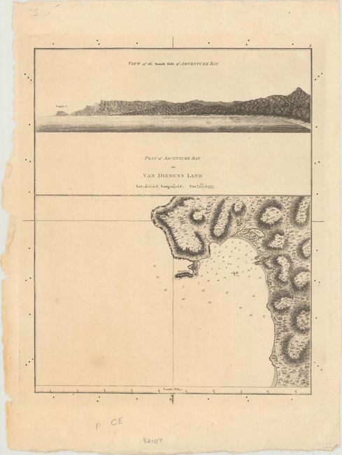
This chart shows Adventure Bay on Bruny Island off the south coast of Tasmania, with north oriented to the bottom of the sheet. There is good detail of the topography of the land, as well as depth soundings and a safe anchorage. Above the chart is a view of the south side of the bay. The bay was initially discovered by Tobias Furneaux, captain of the H.M.S. Adventure, on Capt. Cook's second voyage. Cook returned on his third voyage to the Pacific (1775-1780), when his ships the Resolution and Discovery headed eastward and came upon what they called Van Diemen's Land (Tasmania), which Cook thought was joined to mainland Australia. While anchoring in Adventure Bay to restock supplies of food, water and wood, James Burney, the First Lieutenant on the Discovery sketched the bay, noting depth soundings, a lake, elevations, and the contours of the beach as seen from the ship. The ships stayed only four days in the bay in January 1777 before continuing onward towards New Zealand.
References: Tooley (Australia) #333.
Condition: B+
Light toning with tiny ink spots in the blank margins.