Subject: North Pacific Ocean
Period: 1779 (circa)
Publication: Prevost's Histoire Generale des Voyages
Color: Hand Color
Size:
14.5 x 9.2 inches
36.8 x 23.4 cm
Captain James Cook (1728-1779) is best known for his three voyages to the Pacific (1768-71; 1772-75; and 1776-79). His discoveries radically changed the western understanding of the world in the late 18th century. He was the first to circumnavigate and chart New Zealand and provided the earliest European accounts of exploration along the eastern coast of Australia and the Hawaiian Islands. On February 14th, 1779, he was killed on Hawaii after attempting to kidnap the chief of the island.
Many contemporary accounts of Cook’s voyages, including charts and engravings, appeared in the late 18th century. The first official account of Cook’s first voyage was published in 1773 by John Hawkesworth in Volumes II and III of An Account of the Voyages Undertaken by the Order of His Present Majesty for Making Discoveries in the Southern Hemisphere... William Strahan and Thomas Cadell published the first official accounts of the second and third voyages in 1777 and 1784. Accounts of his exploration were subsequently translated into French, German, and Dutch.
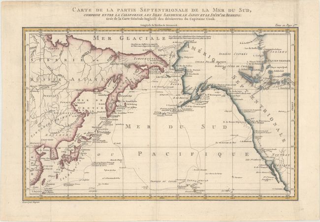
This fine map is based on the Henry Roberts/Cook chart with the addition of China, Japan, and the Sandwich Islands. It details the adjacent coastal areas of Russian Asia from the Bering Strait and the Kamchatka Peninsula down to Japan, Korea, and China, and across to the west coast of North America down to below the Baja Peninsula. The interior of the Northwest is completely blank, but details are beginning to emerge along the coastal areas as the maps names R. De Cook, Port De Norton, the B. De Bristol, Ounalachka, and more. Shows the tracks of Capt. Cook's ships, the Resolution and the Discovery, during Cook's third voyage to the Pacific between 1778 and 1789. Cook traveled from the Sandwich Islands to Nootka and the southern coast of Alaska, where he surveyed Prince William Sound and the Aleutian Islands. He then continued northward through the Bering Strait to the Arctic above the 70th parallel before weather and ice forced his return to the Sandwich Islands. The map features lakes, rivers, mountains and other geographical features. Finely engraved by Dupuis. An uncommon Cook map.
References:
Condition: B+
Issued folding on paper with a bunch of grapes watermark, with very light offsetting.